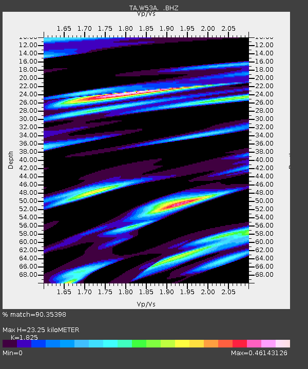
W53A Cullowhee, NC, USA - Earthquake Result Viewer
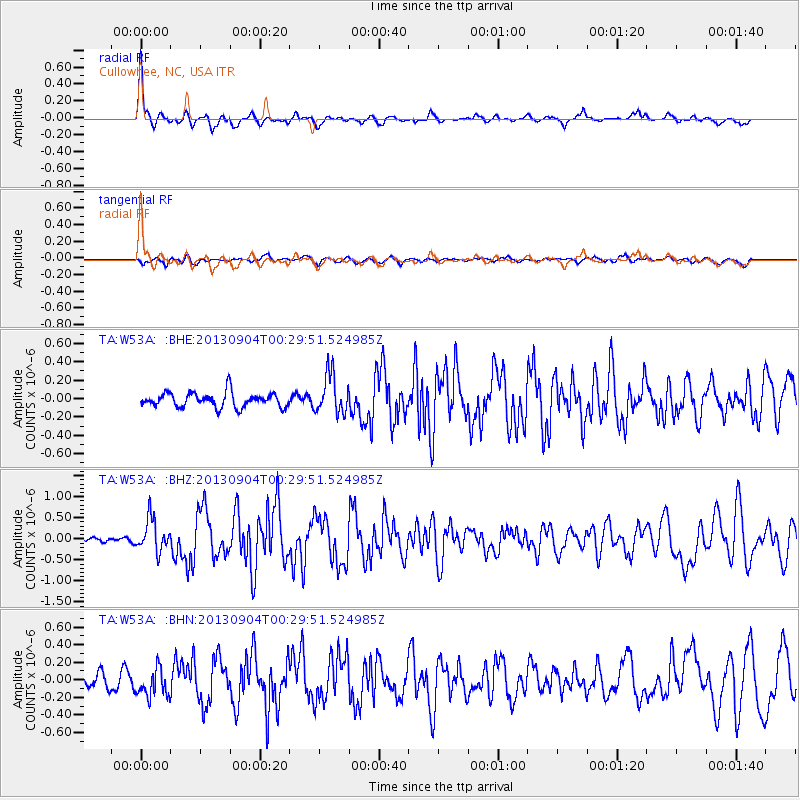
Earthquake location: Queen Charlotte Islands Region
Earthquake latitude/longitude: 51.2/-130.2
Earthquake time(UTC): 2013/09/04 (247) 00:23:11 GMT
Earthquake Depth: 9.9 km
Earthquake Magnitude: 6.0 MW, 5.9 MI, 5.9 MWR, 6.0 MWW, 6.0 MWW, 6.0 MWC
Earthquake Catalog/Contributor: NEIC PDE/NEIC COMCAT
Network: TA USArray Transportable Network (new EarthScope stations)
Station: W53A Cullowhee, NC, USA
Lat/Lon: 35.17 N/83.16 W
Elevation: 1180 m
Distance: 37.2 deg
Az: 96.92 deg
Baz: 310.303 deg
Ray Param: 0.076282434
Estimated Moho Depth: 23.25 km
Estimated Crust Vp/Vs: 1.83
Assumed Crust Vp: 6.35 km/s
Estimated Crust Vs: 3.479 km/s
Estimated Crust Poisson's Ratio: 0.29
Radial Match: 90.35398 %
Radial Bump: 341
Transverse Match: 62.29345 %
Transverse Bump: 400
SOD ConfigId: 626651
Insert Time: 2014-04-18 09:44:25.023 +0000
GWidth: 2.5
Max Bumps: 400
Tol: 0.001

Signal To Noise

ChannelStoNSTALTA
TA:W53A: :BHZ:20130904T00:29:51.524985Z4.3964183.8390638E-78.732254E-8
TA:W53A: :BHN:20130904T00:29:51.524985Z2.08833151.6042213E-77.6818324E-8
TA:W53A: :BHE:20130904T00:29:51.524985Z2.66744022.1132374E-77.922342E-8
Arrivals
Ps3.2 SECOND
PpPs9.6 SECOND
PsPs/PpSs13 SECOND