X54A Belton, SC, USA - Earthquake Result Viewer
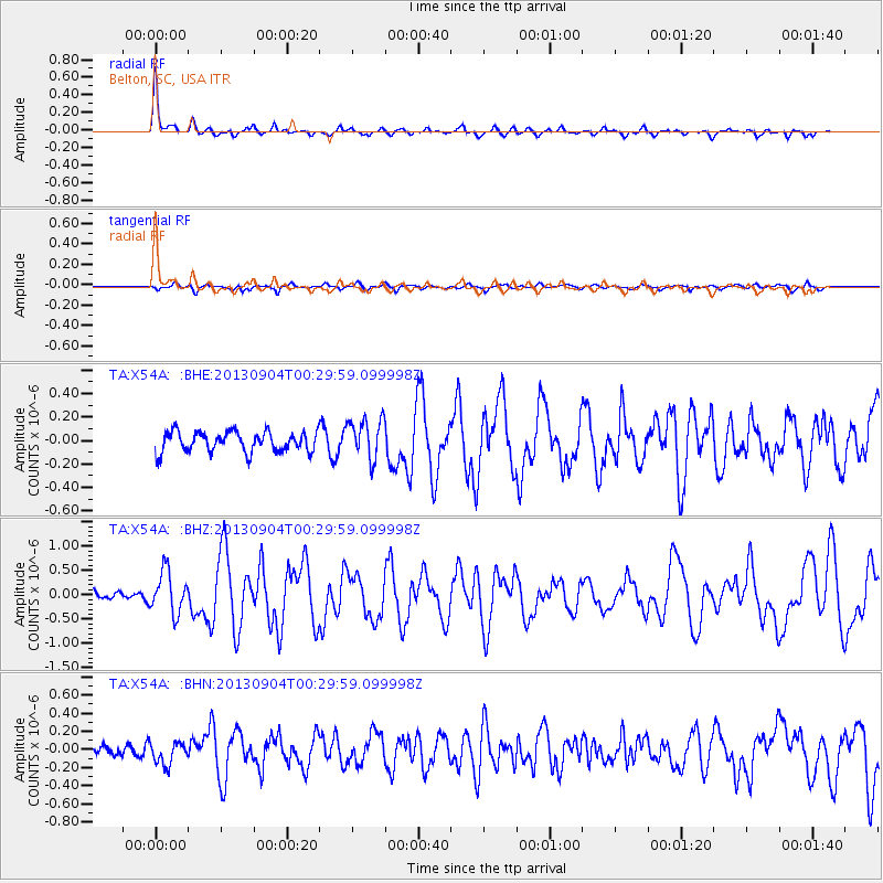
Earthquake location: Queen Charlotte Islands Region
Earthquake latitude/longitude: 51.2/-130.2
Earthquake time(UTC): 2013/09/04 (247) 00:23:11 GMT
Earthquake Depth: 9.9 km
Earthquake Magnitude: 6.0 MW, 5.9 MI, 5.9 MWR, 6.0 MWW, 6.0 MWW, 6.0 MWC
Earthquake Catalog/Contributor: NEIC PDE/NEIC COMCAT
Network: TA USArray Transportable Network (new EarthScope stations)
Station: X54A Belton, SC, USA
Lat/Lon: 34.55 N/82.37 W
Elevation: 213 m
Distance: 38.1 deg
Az: 97.002 deg
Baz: 310.816 deg
Ray Param: 0.07577711
Estimated Moho Depth: 45.0 km
Estimated Crust Vp/Vs: 1.75
Assumed Crust Vp: 6.35 km/s
Estimated Crust Vs: 3.623 km/s
Estimated Crust Poisson's Ratio: 0.26
Radial Match: 86.51767 %
Radial Bump: 315
Transverse Match: 61.23414 %
Transverse Bump: 400
SOD ConfigId: 626651
Insert Time: 2014-04-18 09:44:51.409 +0000
GWidth: 2.5
Max Bumps: 400
Tol: 0.001

Signal To Noise

ChannelStoNSTALTA
TA:X54A: :BHZ:20130904T00:29:59.099998Z2.68260844.2270327E-71.5757175E-7
TA:X54A: :BHN:20130904T00:29:59.099998Z1.10982361.2170858E-71.09664796E-7
TA:X54A: :BHE:20130904T00:29:59.099998Z1.98645681.7157271E-78.637123E-8
Arrivals
Ps5.7 SECOND
PpPs18 SECOND
PsPs/PpSs24 SECOND