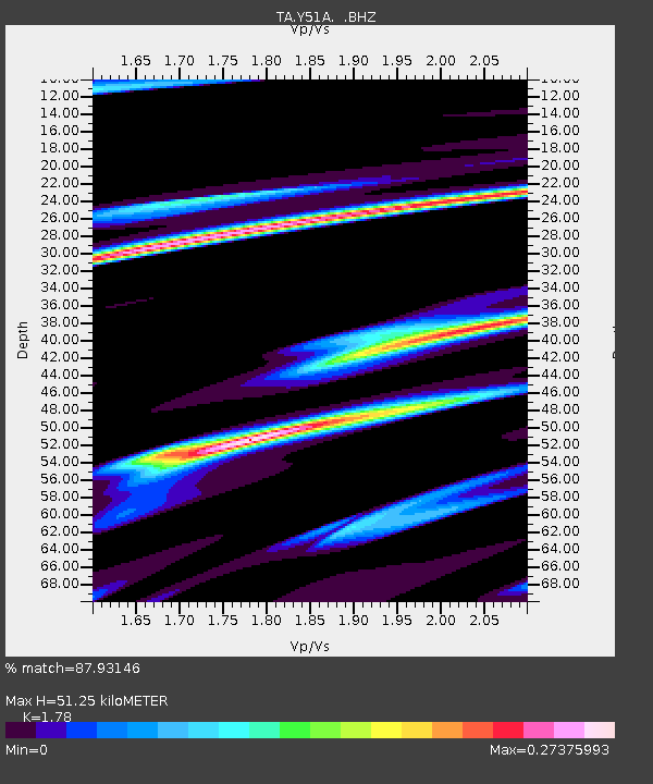
Y51A Rockmart, GA, USA - Earthquake Result Viewer
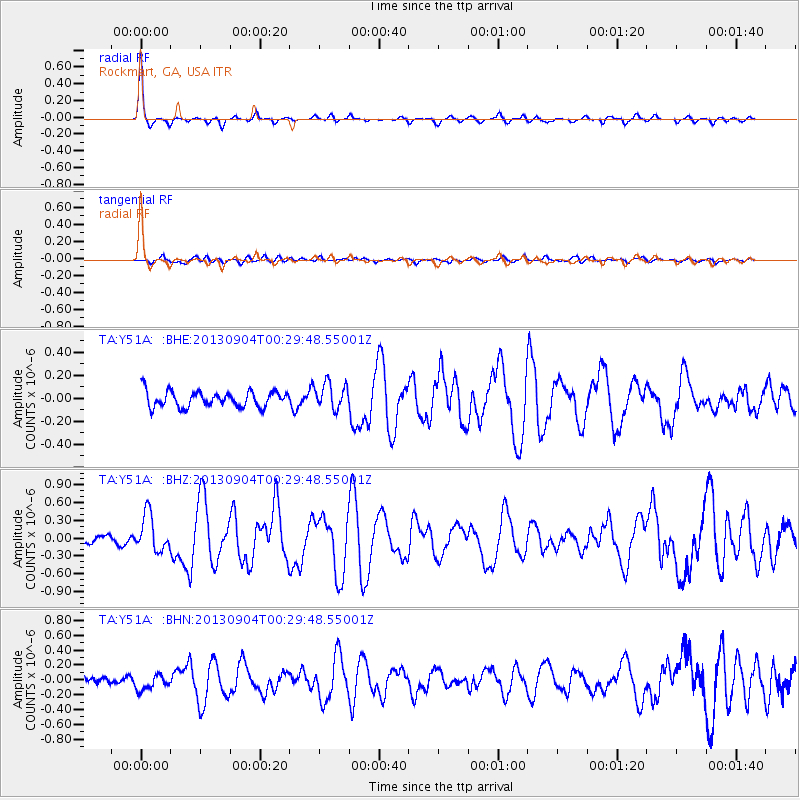
Earthquake location: Queen Charlotte Islands Region
Earthquake latitude/longitude: 51.2/-130.2
Earthquake time(UTC): 2013/09/04 (247) 00:23:11 GMT
Earthquake Depth: 9.9 km
Earthquake Magnitude: 6.0 MW, 5.9 MI, 5.9 MWR, 6.0 MWW, 6.0 MWW, 6.0 MWC
Earthquake Catalog/Contributor: NEIC PDE/NEIC COMCAT
Network: TA USArray Transportable Network (new EarthScope stations)
Station: Y51A Rockmart, GA, USA
Lat/Lon: 33.90 N/85.06 W
Elevation: 380 m
Distance: 36.8 deg
Az: 100.221 deg
Baz: 311.867 deg
Ray Param: 0.07647328
Estimated Moho Depth: 51.25 km
Estimated Crust Vp/Vs: 1.78
Assumed Crust Vp: 6.719 km/s
Estimated Crust Vs: 3.775 km/s
Estimated Crust Poisson's Ratio: 0.27
Radial Match: 87.93146 %
Radial Bump: 255
Transverse Match: 62.806404 %
Transverse Bump: 400
SOD ConfigId: 626651
Insert Time: 2014-04-18 09:45:05.563 +0000
GWidth: 2.5
Max Bumps: 400
Tol: 0.001

Signal To Noise

ChannelStoNSTALTA
TA:Y51A: :BHZ:20130904T00:29:48.55001Z4.0910263.133182E-77.658671E-8
TA:Y51A: :BHN:20130904T00:29:48.55001Z1.77987781.02588935E-75.763819E-8
TA:Y51A: :BHE:20130904T00:29:48.55001Z1.68338221.1453754E-76.804013E-8
Arrivals
Ps6.5 SECOND
PpPs20 SECOND
PsPs/PpSs26 SECOND