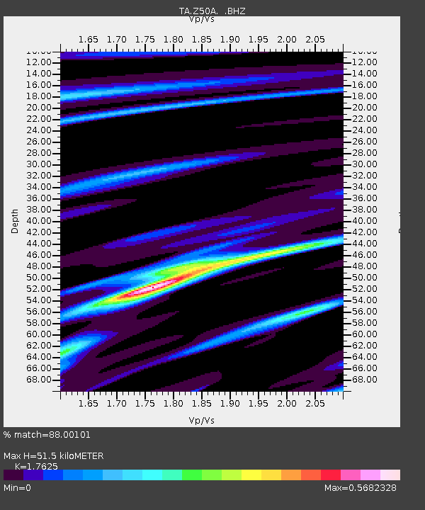
Z50A Ashland, AL, USA - Earthquake Result Viewer

Earthquake location: Queen Charlotte Islands Region
Earthquake latitude/longitude: 51.2/-130.2
Earthquake time(UTC): 2013/09/04 (247) 00:23:11 GMT
Earthquake Depth: 9.9 km
Earthquake Magnitude: 6.0 MW, 5.9 MI, 5.9 MWR, 6.0 MWW, 6.0 MWW, 6.0 MWC
Earthquake Catalog/Contributor: NEIC PDE/NEIC COMCAT
Network: TA USArray Transportable Network (new EarthScope stations)
Station: Z50A Ashland, AL, USA
Lat/Lon: 33.25 N/85.92 W
Elevation: 370 m
Distance: 36.7 deg
Az: 101.822 deg
Baz: 312.677 deg
Ray Param: 0.07652639
Estimated Moho Depth: 51.5 km
Estimated Crust Vp/Vs: 1.76
Assumed Crust Vp: 6.719 km/s
Estimated Crust Vs: 3.812 km/s
Estimated Crust Poisson's Ratio: 0.26
Radial Match: 88.00101 %
Radial Bump: 239
Transverse Match: 52.65848 %
Transverse Bump: 400
SOD ConfigId: 626651
Insert Time: 2014-04-18 09:45:21.001 +0000
GWidth: 2.5
Max Bumps: 400
Tol: 0.001

Signal To Noise

ChannelStoNSTALTA
TA:Z50A: :BHZ:20130904T00:29:47.724998Z4.04090173.6103054E-78.9344056E-8
TA:Z50A: :BHN:20130904T00:29:47.724998Z3.08619742.0957432E-76.7906974E-8
TA:Z50A: :BHE:20130904T00:29:47.724998Z2.96492742.2073594E-77.444903E-8
Arrivals
Ps6.3 SECOND
PpPs19 SECOND
PsPs/PpSs26 SECOND