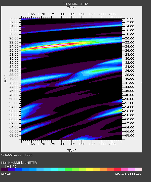
SENIN Lac Selin/Sanetsch - Earthquake Result Viewer

Earthquake location: Andreanof Islands, Aleutian Is.
Earthquake latitude/longitude: 51.6/-174.8
Earthquake time(UTC): 2013/09/04 (247) 02:32:30 GMT
Earthquake Depth: 20 km
Earthquake Magnitude: 6.5 MWW, 5.9 ML, 6.3 MWB, 6.5 MI, 6.5 MWC, 6.5 MWW
Earthquake Catalog/Contributor: NEIC PDE/NEIC COMCAT
Network: CH Switzerland Seismological Network
Station: SENIN Lac Selin/Sanetsch
Lat/Lon: 46.36 N/7.30 E
Elevation: 2035 m
Distance: 82.4 deg
Az: 358.557 deg
Baz: 1.301 deg
Ray Param: 0.04686619
Estimated Moho Depth: 23.5 km
Estimated Crust Vp/Vs: 1.75
Assumed Crust Vp: 6.276 km/s
Estimated Crust Vs: 3.586 km/s
Estimated Crust Poisson's Ratio: 0.26
Radial Match: 92.81996 %
Radial Bump: 400
Transverse Match: 74.545235 %
Transverse Bump: 400
SOD ConfigId: 626651
Insert Time: 2014-04-18 09:50:46.762 +0000
GWidth: 2.5
Max Bumps: 400
Tol: 0.001

Signal To Noise

ChannelStoNSTALTA
CH:SENIN: :HHZ:20130904T02:44:20.013025Z12.1016741.2669808E-61.0469468E-7
CH:SENIN: :HHN:20130904T02:44:20.013025Z5.49806174.948917E-79.001203E-8
CH:SENIN: :HHE:20130904T02:44:20.013025Z1.34384271.2285152E-79.141807E-8
Arrivals
Ps2.9 SECOND
PpPs10 SECOND
PsPs/PpSs13 SECOND