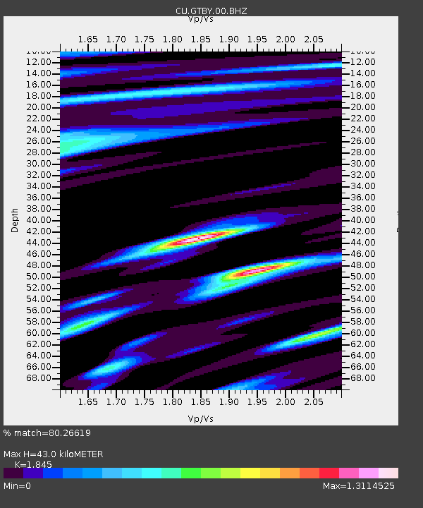
GTBY Guantanamo Bay, Cuba - Earthquake Result Viewer

Earthquake location: Andreanof Islands, Aleutian Is.
Earthquake latitude/longitude: 51.6/-174.8
Earthquake time(UTC): 2013/09/04 (247) 02:32:30 GMT
Earthquake Depth: 20 km
Earthquake Magnitude: 6.5 MWW, 5.9 ML, 6.3 MWB, 6.5 MI, 6.5 MWC, 6.5 MWW
Earthquake Catalog/Contributor: NEIC PDE/NEIC COMCAT
Network: CU Caribbean Network (USGS)
Station: GTBY Guantanamo Bay, Cuba
Lat/Lon: 19.93 N/75.11 W
Elevation: 79 m
Distance: 80.4 deg
Az: 70.153 deg
Baz: 321.382 deg
Ray Param: 0.04825951
Estimated Moho Depth: 43.0 km
Estimated Crust Vp/Vs: 1.85
Assumed Crust Vp: 6.048 km/s
Estimated Crust Vs: 3.278 km/s
Estimated Crust Poisson's Ratio: 0.29
Radial Match: 80.26619 %
Radial Bump: 400
Transverse Match: 78.71789 %
Transverse Bump: 400
SOD ConfigId: 626651
Insert Time: 2014-04-18 09:53:52.574 +0000
GWidth: 2.5
Max Bumps: 400
Tol: 0.001

Signal To Noise

ChannelStoNSTALTA
CU:GTBY:00:BHZ:20130904T02:44:09.449976Z3.35410627.352879E-72.1922023E-7
CU:GTBY:00:BH1:20130904T02:44:09.449976Z1.50696643.9731992E-72.6365547E-7
CU:GTBY:00:BH2:20130904T02:44:09.449976Z1.06193962.0244573E-71.906377E-7
Arrivals
Ps6.2 SECOND
PpPs20 SECOND
PsPs/PpSs26 SECOND