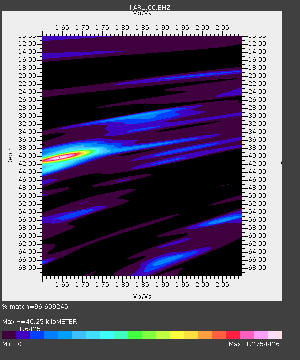
ARU Arti, Russia - Earthquake Result Viewer

Earthquake location: Irian Jaya Region, Indonesia
Earthquake latitude/longitude: -0.4/133.1
Earthquake time(UTC): 2004/07/28 (210) 03:56:28 GMT
Earthquake Depth: 13 km
Earthquake Magnitude: 6.0 MB, 6.3 MS, 6.5 MW, 6.4 MW
Earthquake Catalog/Contributor: WHDF/NEIC
Network: II Global Seismograph Network (GSN - IRIS/IDA)
Station: ARU Arti, Russia
Lat/Lon: 56.43 N/58.56 E
Elevation: 250 m
Distance: 81.8 deg
Az: 327.257 deg
Baz: 103.202 deg
Ray Param: 0.047292475
Estimated Moho Depth: 40.25 km
Estimated Crust Vp/Vs: 1.64
Assumed Crust Vp: 6.159 km/s
Estimated Crust Vs: 3.75 km/s
Estimated Crust Poisson's Ratio: 0.21
Radial Match: 96.609245 %
Radial Bump: 271
Transverse Match: 90.84653 %
Transverse Bump: 400
SOD ConfigId: 2459
Insert Time: 2010-03-01 16:32:14.731 +0000
GWidth: 2.5
Max Bumps: 400
Tol: 0.001

Signal To Noise

ChannelStoNSTALTA
II:ARU:00:BHN:20040728T04:08:15.90603Z3.9455332.6840448E-76.802743E-8
II:ARU:00:BHE:20040728T04:08:15.907007Z21.143748.474869E-74.0082167E-8
II:ARU:00:BHZ:20040728T04:08:15.907007Z33.2155572.3001473E-66.92491E-8
Arrivals
Ps4.3 SECOND
PpPs17 SECOND
PsPs/PpSs21 SECOND