NIL Nilore, Pakistan - Earthquake Result Viewer
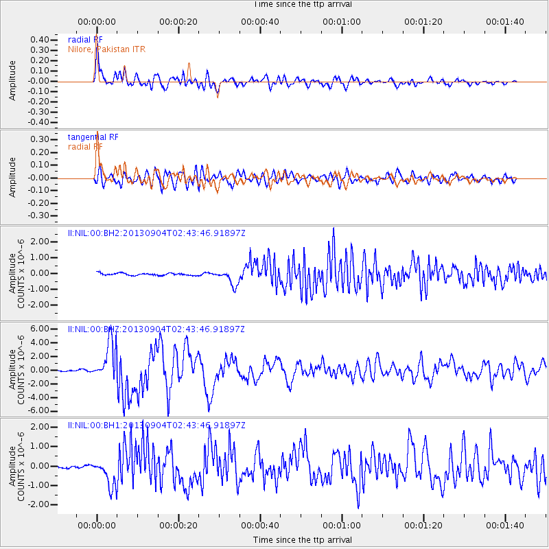
Earthquake location: Andreanof Islands, Aleutian Is.
Earthquake latitude/longitude: 51.6/-174.8
Earthquake time(UTC): 2013/09/04 (247) 02:32:30 GMT
Earthquake Depth: 20 km
Earthquake Magnitude: 6.5 MWW, 5.9 ML, 6.3 MWB, 6.5 MI, 6.5 MWC, 6.5 MWW
Earthquake Catalog/Contributor: NEIC PDE/NEIC COMCAT
Network: II Global Seismograph Network (GSN - IRIS/IDA)
Station: NIL Nilore, Pakistan
Lat/Lon: 33.65 N/73.27 E
Elevation: 629 m
Distance: 76.3 deg
Az: 307.24 deg
Baz: 36.571 deg
Ray Param: 0.051038492
Estimated Moho Depth: 47.25 km
Estimated Crust Vp/Vs: 1.88
Assumed Crust Vp: 6.242 km/s
Estimated Crust Vs: 3.311 km/s
Estimated Crust Poisson's Ratio: 0.30
Radial Match: 91.302216 %
Radial Bump: 400
Transverse Match: 83.11915 %
Transverse Bump: 400
SOD ConfigId: 626651
Insert Time: 2014-04-18 09:58:09.448 +0000
GWidth: 2.5
Max Bumps: 400
Tol: 0.001

Signal To Noise

ChannelStoNSTALTA
II:NIL:00:BHZ:20130904T02:43:46.91897Z33.887622.9479093E-68.6990745E-8
II:NIL:00:BH1:20130904T02:43:46.91897Z9.2579677.2725067E-77.855403E-8
II:NIL:00:BH2:20130904T02:43:46.91897Z7.03560455.047225E-77.173833E-8
Arrivals
Ps6.9 SECOND
PpPs21 SECOND
PsPs/PpSs28 SECOND