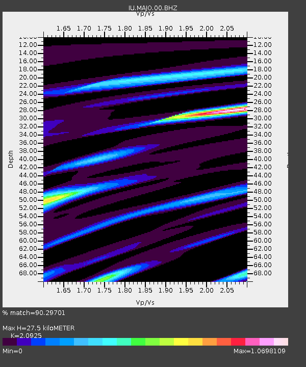
MAJO Matsushiro, Japan - Earthquake Result Viewer

Earthquake location: Andreanof Islands, Aleutian Is.
Earthquake latitude/longitude: 51.6/-174.8
Earthquake time(UTC): 2013/09/04 (247) 02:32:30 GMT
Earthquake Depth: 20 km
Earthquake Magnitude: 6.5 MWW, 5.9 ML, 6.3 MWB, 6.5 MI, 6.5 MWC, 6.5 MWW
Earthquake Catalog/Contributor: NEIC PDE/NEIC COMCAT
Network: IU Global Seismograph Network (GSN - IRIS/USGS)
Station: MAJO Matsushiro, Japan
Lat/Lon: 36.55 N/138.20 E
Elevation: 405 m
Distance: 36.3 deg
Az: 264.314 deg
Baz: 50.482 deg
Ray Param: 0.07672635
Estimated Moho Depth: 27.5 km
Estimated Crust Vp/Vs: 2.09
Assumed Crust Vp: 6.461 km/s
Estimated Crust Vs: 3.088 km/s
Estimated Crust Poisson's Ratio: 0.35
Radial Match: 90.29701 %
Radial Bump: 400
Transverse Match: 75.99768 %
Transverse Bump: 400
SOD ConfigId: 626651
Insert Time: 2014-04-18 09:58:56.050 +0000
GWidth: 2.5
Max Bumps: 400
Tol: 0.001

Signal To Noise

ChannelStoNSTALTA
IU:MAJO:00:BHZ:20130904T02:39:02.119012Z32.080112.81983E-68.7899636E-8
IU:MAJO:00:BH1:20130904T02:39:02.119012Z8.0224291.0127643E-61.2624159E-7
IU:MAJO:00:BH2:20130904T02:39:02.119012Z10.4758661.2034058E-61.1487411E-7
Arrivals
Ps5.0 SECOND
PpPs12 SECOND
PsPs/PpSs17 SECOND