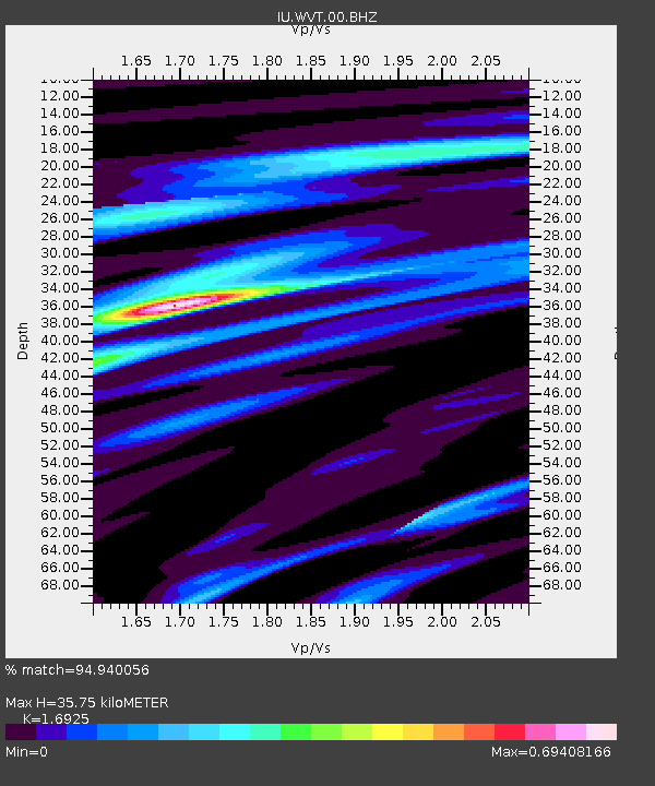
WVT Waverly, Tennessee, USA - Earthquake Result Viewer
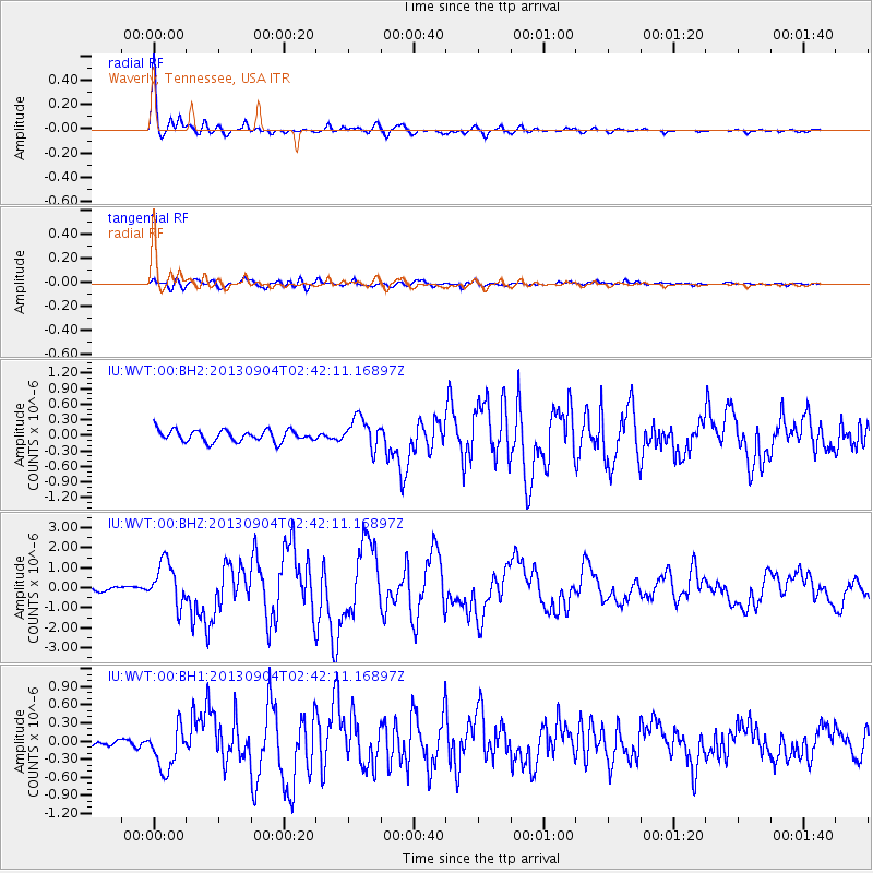
Earthquake location: Andreanof Islands, Aleutian Is.
Earthquake latitude/longitude: 51.6/-174.8
Earthquake time(UTC): 2013/09/04 (247) 02:32:30 GMT
Earthquake Depth: 20 km
Earthquake Magnitude: 6.5 MWW, 5.9 ML, 6.3 MWB, 6.5 MI, 6.5 MWC, 6.5 MWW
Earthquake Catalog/Contributor: NEIC PDE/NEIC COMCAT
Network: IU Global Seismograph Network (GSN - IRIS/USGS)
Station: WVT Waverly, Tennessee, USA
Lat/Lon: 36.13 N/87.83 W
Elevation: 170 m
Distance: 60.9 deg
Az: 67.631 deg
Baz: 314.511 deg
Ray Param: 0.061171908
Estimated Moho Depth: 35.75 km
Estimated Crust Vp/Vs: 1.69
Assumed Crust Vp: 6.444 km/s
Estimated Crust Vs: 3.807 km/s
Estimated Crust Poisson's Ratio: 0.23
Radial Match: 94.940056 %
Radial Bump: 337
Transverse Match: 80.08654 %
Transverse Bump: 400
SOD ConfigId: 626651
Insert Time: 2014-04-18 09:59:29.094 +0000
GWidth: 2.5
Max Bumps: 400
Tol: 0.001

Signal To Noise

ChannelStoNSTALTA
IU:WVT:00:BHZ:20130904T02:42:11.16897Z10.4157341.083394E-61.0401513E-7
IU:WVT:00:BH1:20130904T02:42:11.16897Z5.83435063.735499E-76.402596E-8
IU:WVT:00:BH2:20130904T02:42:11.16897Z2.63251612.9042687E-71.10322915E-7
Arrivals
Ps4.0 SECOND
PpPs14 SECOND
PsPs/PpSs18 SECOND