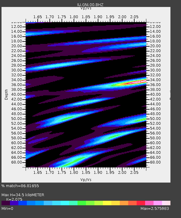
GNI Garni, Armenia - Earthquake Result Viewer
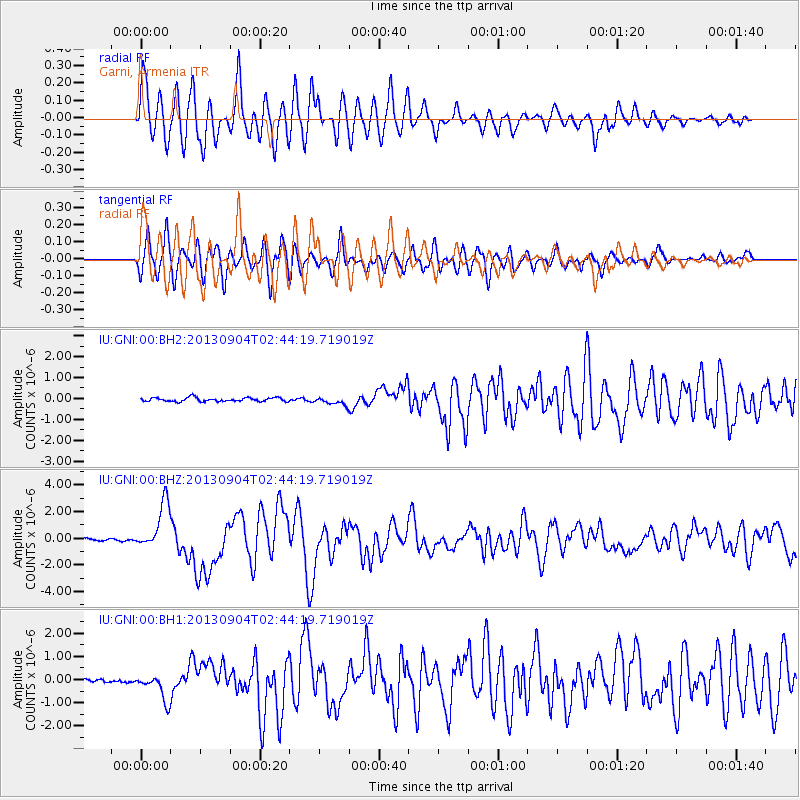
Earthquake location: Andreanof Islands, Aleutian Is.
Earthquake latitude/longitude: 51.6/-174.8
Earthquake time(UTC): 2013/09/04 (247) 02:32:30 GMT
Earthquake Depth: 20 km
Earthquake Magnitude: 6.5 MWW, 5.9 ML, 6.3 MWB, 6.5 MI, 6.5 MWC, 6.5 MWW
Earthquake Catalog/Contributor: NEIC PDE/NEIC COMCAT
Network: IU Global Seismograph Network (GSN - IRIS/USGS)
Station: GNI Garni, Armenia
Lat/Lon: 40.15 N/44.74 E
Elevation: 1609 m
Distance: 82.4 deg
Az: 330.529 deg
Baz: 23.622 deg
Ray Param: 0.046905894
Estimated Moho Depth: 34.5 km
Estimated Crust Vp/Vs: 2.08
Assumed Crust Vp: 6.291 km/s
Estimated Crust Vs: 3.032 km/s
Estimated Crust Poisson's Ratio: 0.35
Radial Match: 86.81655 %
Radial Bump: 400
Transverse Match: 83.230965 %
Transverse Bump: 400
SOD ConfigId: 626651
Insert Time: 2014-04-18 09:59:35.626 +0000
GWidth: 2.5
Max Bumps: 400
Tol: 0.001

Signal To Noise

ChannelStoNSTALTA
IU:GNI:00:BHZ:20130904T02:44:19.719019Z22.712411.748551E-67.698659E-8
IU:GNI:00:BH1:20130904T02:44:19.719019Z9.0153995.719751E-76.344423E-8
IU:GNI:00:BH2:20130904T02:44:19.719019Z2.08747721.8470952E-78.848457E-8
Arrivals
Ps6.0 SECOND
PpPs17 SECOND
PsPs/PpSs23 SECOND