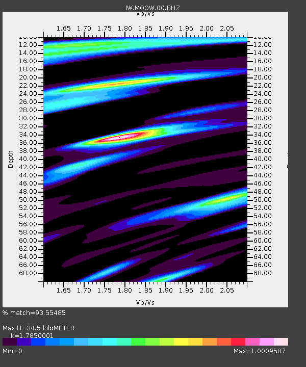
MOOW Moose Ponds, Wyoming, USA - Earthquake Result Viewer
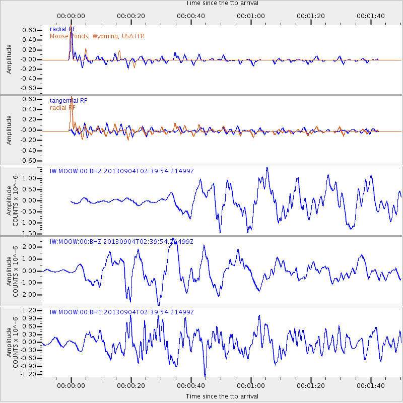
Earthquake location: Andreanof Islands, Aleutian Is.
Earthquake latitude/longitude: 51.6/-174.8
Earthquake time(UTC): 2013/09/04 (247) 02:32:30 GMT
Earthquake Depth: 20 km
Earthquake Magnitude: 6.5 MWW, 5.9 ML, 6.3 MWB, 6.5 MI, 6.5 MWC, 6.5 MWW
Earthquake Catalog/Contributor: NEIC PDE/NEIC COMCAT
Network: IW Intermountain West
Station: MOOW Moose Ponds, Wyoming, USA
Lat/Lon: 43.75 N/110.74 W
Elevation: 2128 m
Distance: 42.6 deg
Az: 74.375 deg
Baz: 303.941 deg
Ray Param: 0.07307515
Estimated Moho Depth: 34.5 km
Estimated Crust Vp/Vs: 1.79
Assumed Crust Vp: 6.207 km/s
Estimated Crust Vs: 3.477 km/s
Estimated Crust Poisson's Ratio: 0.27
Radial Match: 93.55485 %
Radial Bump: 400
Transverse Match: 73.63066 %
Transverse Bump: 400
SOD ConfigId: 626651
Insert Time: 2014-04-18 09:59:56.305 +0000
GWidth: 2.5
Max Bumps: 400
Tol: 0.001

Signal To Noise

ChannelStoNSTALTA
IW:MOOW:00:BHZ:20130904T02:39:54.21499Z2.95488333.6168828E-71.2240358E-7
IW:MOOW:00:BH1:20130904T02:39:54.21499Z1.95607541.793724E-79.170015E-8
IW:MOOW:00:BH2:20130904T02:39:54.21499Z2.4241162.0113585E-78.297287E-8
Arrivals
Ps4.6 SECOND
PpPs15 SECOND
PsPs/PpSs19 SECOND