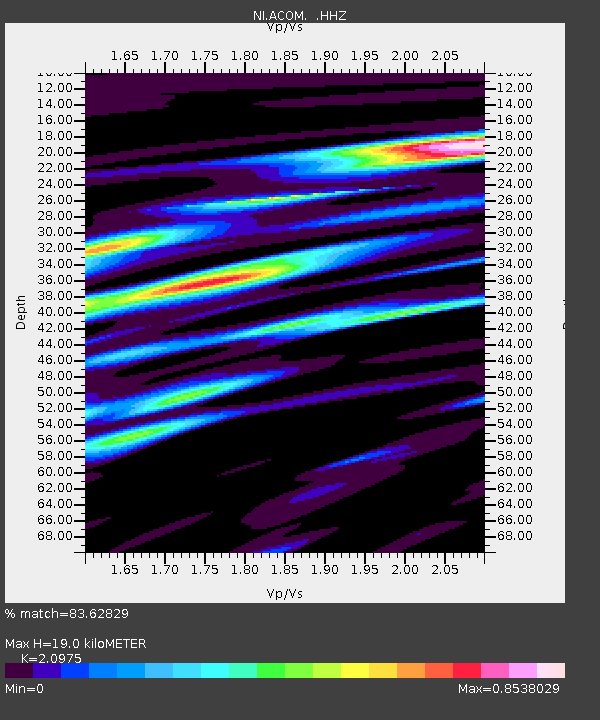
ACOM Acomizza - Earthquake Result Viewer

Earthquake location: Andreanof Islands, Aleutian Is.
Earthquake latitude/longitude: 51.6/-174.8
Earthquake time(UTC): 2013/09/04 (247) 02:32:30 GMT
Earthquake Depth: 20 km
Earthquake Magnitude: 6.5 MWW, 5.9 ML, 6.3 MWB, 6.5 MI, 6.5 MWC, 6.5 MWW
Earthquake Catalog/Contributor: NEIC PDE/NEIC COMCAT
Network: NI North-East Italy Broadband Network
Station: ACOM Acomizza
Lat/Lon: 46.55 N/13.51 E
Elevation: 1788 m
Distance: 82.0 deg
Az: 354.239 deg
Baz: 5.209 deg
Ray Param: 0.04716336
Estimated Moho Depth: 19.0 km
Estimated Crust Vp/Vs: 2.10
Assumed Crust Vp: 6.35 km/s
Estimated Crust Vs: 3.027 km/s
Estimated Crust Poisson's Ratio: 0.35
Radial Match: 83.62829 %
Radial Bump: 400
Transverse Match: 68.70616 %
Transverse Bump: 400
SOD ConfigId: 626651
Insert Time: 2014-04-18 10:03:22.282 +0000
GWidth: 2.5
Max Bumps: 400
Tol: 0.001

Signal To Noise

ChannelStoNSTALTA
NI:ACOM: :HHZ:20130904T02:44:17.777979Z10.15545751.2022123E-61.1838091E-7
NI:ACOM: :HHN:20130904T02:44:17.777979Z2.1323692.1596342E-71.0127863E-7
NI:ACOM: :HHE:20130904T02:44:17.777979Z1.46387911.2624704E-78.624145E-8
Arrivals
Ps3.4 SECOND
PpPs9.1 SECOND
PsPs/PpSs12 SECOND