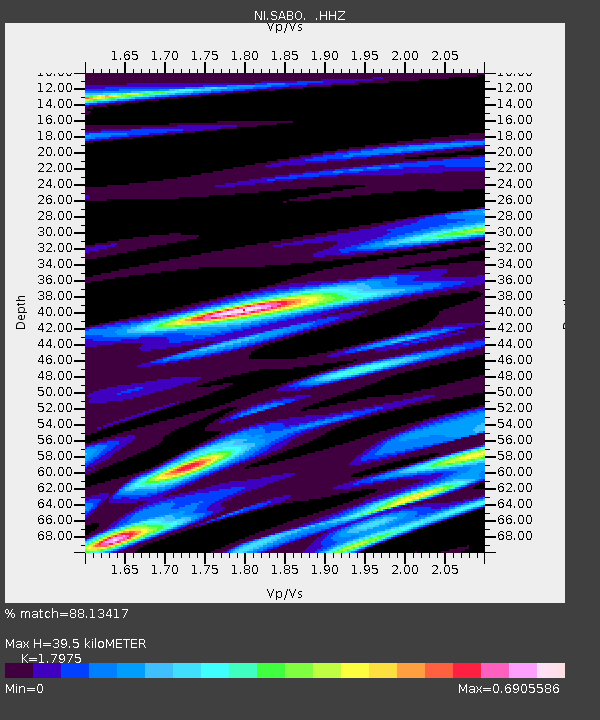
SABO Mt. Sabotino - Earthquake Result Viewer

Earthquake location: Andreanof Islands, Aleutian Is.
Earthquake latitude/longitude: 51.6/-174.8
Earthquake time(UTC): 2013/09/04 (247) 02:32:30 GMT
Earthquake Depth: 20 km
Earthquake Magnitude: 6.5 MWW, 5.9 ML, 6.3 MWB, 6.5 MI, 6.5 MWC, 6.5 MWW
Earthquake Catalog/Contributor: NEIC PDE/NEIC COMCAT
Network: NI North-East Italy Broadband Network
Station: SABO Mt. Sabotino
Lat/Lon: 45.99 N/13.63 E
Elevation: 621 m
Distance: 82.6 deg
Az: 354.104 deg
Baz: 5.277 deg
Ray Param: 0.046781257
Estimated Moho Depth: 39.5 km
Estimated Crust Vp/Vs: 1.80
Assumed Crust Vp: 6.207 km/s
Estimated Crust Vs: 3.453 km/s
Estimated Crust Poisson's Ratio: 0.28
Radial Match: 88.13417 %
Radial Bump: 400
Transverse Match: 71.35091 %
Transverse Bump: 400
SOD ConfigId: 626651
Insert Time: 2014-04-18 10:03:40.434 +0000
GWidth: 2.5
Max Bumps: 400
Tol: 0.001

Signal To Noise

ChannelStoNSTALTA
NI:SABO: :HHZ:20130904T02:44:20.647974Z9.3137441.1052273E-61.1866627E-7
NI:SABO: :HHN:20130904T02:44:20.647974Z6.15519955.428098E-78.81872E-8
NI:SABO: :HHE:20130904T02:44:20.647974Z1.81469361.6009598E-78.8222045E-8
Arrivals
Ps5.2 SECOND
PpPs17 SECOND
PsPs/PpSs23 SECOND