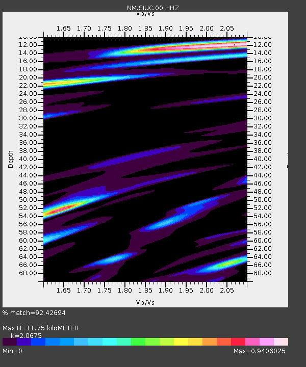
SIUC Carbondale, IL - Earthquake Result Viewer

Earthquake location: Andreanof Islands, Aleutian Is.
Earthquake latitude/longitude: 51.6/-174.8
Earthquake time(UTC): 2013/09/04 (247) 02:32:30 GMT
Earthquake Depth: 20 km
Earthquake Magnitude: 6.5 MWW, 5.9 ML, 6.3 MWB, 6.5 MI, 6.5 MWC, 6.5 MWW
Earthquake Catalog/Contributor: NEIC PDE/NEIC COMCAT
Network: NM Cooperative New Madrid Seismic Network
Station: SIUC Carbondale, IL
Lat/Lon: 37.71 N/89.22 W
Elevation: 120 m
Distance: 59.1 deg
Az: 67.209 deg
Baz: 313.469 deg
Ray Param: 0.062421784
Estimated Moho Depth: 11.75 km
Estimated Crust Vp/Vs: 2.07
Assumed Crust Vp: 6.444 km/s
Estimated Crust Vs: 3.117 km/s
Estimated Crust Poisson's Ratio: 0.35
Radial Match: 92.42694 %
Radial Bump: 400
Transverse Match: 78.051384 %
Transverse Bump: 400
SOD ConfigId: 626651
Insert Time: 2014-04-18 10:04:23.973 +0000
GWidth: 2.5
Max Bumps: 400
Tol: 0.001

Signal To Noise

ChannelStoNSTALTA
NM:SIUC:00:HHZ:20130904T02:41:58.078027Z6.9652078.344869E-71.1980791E-7
NM:SIUC:00:HHN:20130904T02:41:58.078027Z3.36250933.5765936E-71.063668E-7
NM:SIUC:00:HHE:20130904T02:41:58.078027Z2.25131773.900129E-71.7323761E-7
Arrivals
Ps2.0 SECOND
PpPs5.4 SECOND
PsPs/PpSs7.4 SECOND