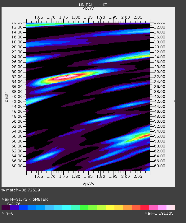
PAH Pah Rah Range, Nevada w84gm - Earthquake Result Viewer

Earthquake location: Andreanof Islands, Aleutian Is.
Earthquake latitude/longitude: 51.6/-174.8
Earthquake time(UTC): 2013/09/04 (247) 02:32:30 GMT
Earthquake Depth: 20 km
Earthquake Magnitude: 6.5 MWW, 5.9 ML, 6.3 MWB, 6.5 MI, 6.5 MWC, 6.5 MWW
Earthquake Catalog/Contributor: NEIC PDE/NEIC COMCAT
Network: NN Western Great Basin/Eastern Sierra Nevada
Station: PAH Pah Rah Range, Nevada w84gm
Lat/Lon: 39.71 N/119.39 W
Elevation: 1520 m
Distance: 39.6 deg
Az: 85.054 deg
Baz: 306.264 deg
Ray Param: 0.07487564
Estimated Moho Depth: 31.75 km
Estimated Crust Vp/Vs: 1.76
Assumed Crust Vp: 6.279 km/s
Estimated Crust Vs: 3.567 km/s
Estimated Crust Poisson's Ratio: 0.26
Radial Match: 86.72519 %
Radial Bump: 400
Transverse Match: 75.467514 %
Transverse Bump: 400
SOD ConfigId: 626651
Insert Time: 2014-04-18 10:04:43.331 +0000
GWidth: 2.5
Max Bumps: 400
Tol: 0.001

Signal To Noise

ChannelStoNSTALTA
NN:PAH: :HHZ:20130904T02:39:29.684991Z2.79356933.500271E-71.2529745E-7
NN:PAH: :HHN:20130904T02:39:29.684991Z1.97776392.0729068E-71.0481063E-7
NN:PAH: :HHE:20130904T02:39:29.684991Z1.87458051.9677037E-71.0496768E-7
Arrivals
Ps4.1 SECOND
PpPs13 SECOND
PsPs/PpSs17 SECOND