You are here: Home > Network List > TA - USArray Transportable Network (new EarthScope stations) Stations List
> Station K02D Willamette Meridian, OR, USA > Earthquake Result Viewer
K02D Willamette Meridian, OR, USA - Earthquake Result Viewer
| Earthquake location: |
Off E. Coast Of N. Island, N.Z. |
| Earthquake latitude/longitude: |
-37.7/179.7 |
| Earthquake time(UTC): |
2014/11/16 (320) 22:33:20 GMT |
| Earthquake Depth: |
22 km |
| Earthquake Magnitude: |
6.7 MWW, 6.7 MWC, 6.7 MI |
| Earthquake Catalog/Contributor: |
NEIC PDE/NEIC COMCAT |
|
| Network: |
TA USArray Transportable Network (new EarthScope stations) |
| Station: |
K02D Willamette Meridian, OR, USA |
| Lat/Lon: |
42.70 N/123.67 W |
| Elevation: |
989 m |
|
| Distance: |
95.1 deg |
| Az: |
38.194 deg |
| Baz: |
221.715 deg |
| Ray Param: |
0.040852584 |
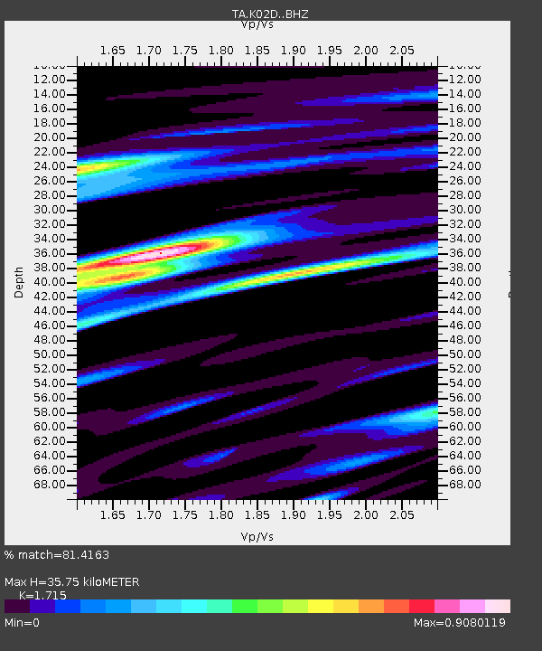
| Estimated Moho Depth: |
35.75 km |
| Estimated Crust Vp/Vs: |
1.72 |
| Assumed Crust Vp: |
6.522 km/s |
| Estimated Crust Vs: |
3.803 km/s |
| Estimated Crust Poisson's Ratio: |
0.24 |
|
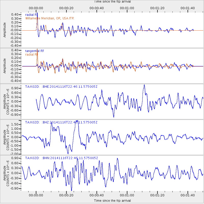
| Radial Match: |
81.4163 % |
| Radial Bump: |
400 |
| Transverse Match: |
48.854218 % |
| Transverse Bump: |
400 |
| SOD ConfigId: |
3390531 |
| Insert Time: |
2019-04-15 01:13:16.106 +0000 |
| GWidth: |
2.5 |
| Max Bumps: |
400 |
| Tol: |
0.001 |
|
Signal To Noise
| Channel | StoN | STA | LTA |
| TA:K02D: :BHZ:20141116T22:46:11.575005Z | 1.1154797 | 1.9401588E-7 | 1.7393045E-7 |
| TA:K02D: :BHN:20141116T22:46:11.575005Z | 0.46263418 | 1.2767875E-7 | 2.7598207E-7 |
| TA:K02D: :BHE:20141116T22:46:11.575005Z | 1.3000786 | 2.9814126E-7 | 2.2932555E-7 |
| Arrivals |
| Ps | 4.0 SECOND |
| PpPs | 15 SECOND |
| PsPs/PpSs | 19 SECOND |


