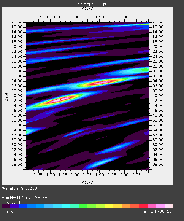
DELO DELORO MINE, ON - Earthquake Result Viewer

Earthquake location: Andreanof Islands, Aleutian Is.
Earthquake latitude/longitude: 51.6/-174.8
Earthquake time(UTC): 2013/09/04 (247) 02:32:30 GMT
Earthquake Depth: 20 km
Earthquake Magnitude: 6.5 MWW, 5.9 ML, 6.3 MWB, 6.5 MI, 6.5 MWC, 6.5 MWW
Earthquake Catalog/Contributor: NEIC PDE/NEIC COMCAT
Network: PO Portable Observatories for Lithospheric Analysis and Research Investigating Seis
Station: DELO DELORO MINE, ON
Lat/Lon: 44.52 N/77.62 W
Elevation: 213 m
Distance: 60.6 deg
Az: 54.53 deg
Baz: 314.707 deg
Ray Param: 0.06137485
Estimated Moho Depth: 41.25 km
Estimated Crust Vp/Vs: 1.74
Assumed Crust Vp: 6.577 km/s
Estimated Crust Vs: 3.78 km/s
Estimated Crust Poisson's Ratio: 0.25
Radial Match: 94.2218 %
Radial Bump: 370
Transverse Match: 82.361534 %
Transverse Bump: 400
SOD ConfigId: 626651
Insert Time: 2014-04-18 10:06:42.105 +0000
GWidth: 2.5
Max Bumps: 400
Tol: 0.001

Signal To Noise

ChannelStoNSTALTA
PO:DELO: :HHZ:20130904T02:42:09.050012Z28.977161.2504145E-64.3151726E-8
PO:DELO: :HHN:20130904T02:42:09.050012Z9.1293743.6497408E-73.9977998E-8
PO:DELO: :HHE:20130904T02:42:09.050012Z7.69260844.035418E-75.2458383E-8
Arrivals
Ps4.9 SECOND
PpPs16 SECOND
PsPs/PpSs21 SECOND