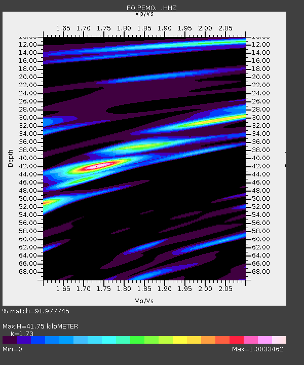
PEMO PEMBROKE, ON - Earthquake Result Viewer

Earthquake location: Andreanof Islands, Aleutian Is.
Earthquake latitude/longitude: 51.6/-174.8
Earthquake time(UTC): 2013/09/04 (247) 02:32:30 GMT
Earthquake Depth: 20 km
Earthquake Magnitude: 6.5 MWW, 5.9 ML, 6.3 MWB, 6.5 MI, 6.5 MWC, 6.5 MWW
Earthquake Catalog/Contributor: NEIC PDE/NEIC COMCAT
Network: PO Portable Observatories for Lithospheric Analysis and Research Investigating Seis
Station: PEMO PEMBROKE, ON
Lat/Lon: 45.68 N/77.25 W
Elevation: 180 m
Distance: 60.0 deg
Az: 53.366 deg
Baz: 314.393 deg
Ray Param: 0.06178698
Estimated Moho Depth: 41.75 km
Estimated Crust Vp/Vs: 1.73
Assumed Crust Vp: 6.577 km/s
Estimated Crust Vs: 3.802 km/s
Estimated Crust Poisson's Ratio: 0.25
Radial Match: 91.977745 %
Radial Bump: 400
Transverse Match: 68.53286 %
Transverse Bump: 400
SOD ConfigId: 626651
Insert Time: 2014-04-18 10:07:14.949 +0000
GWidth: 2.5
Max Bumps: 400
Tol: 0.001

Signal To Noise

ChannelStoNSTALTA
PO:PEMO: :HHZ:20130904T02:42:04.769983Z8.0413967.775559E-79.669414E-8
PO:PEMO: :HHN:20130904T02:42:04.769983Z5.43553353.1980764E-75.883648E-8
PO:PEMO: :HHE:20130904T02:42:04.769983Z4.6451262.5893232E-75.57428E-8
Arrivals
Ps4.9 SECOND
PpPs16 SECOND
PsPs/PpSs21 SECOND