You are here: Home > Network List > UW - Pacific Northwest Regional Seismic Network Stations List
> Station LCCR Mulino, OR, USA > Earthquake Result Viewer
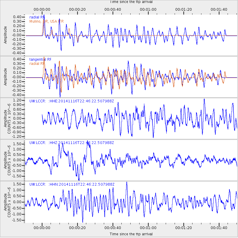
LCCR Mulino, OR, USA - Earthquake Result Viewer
*The percent match for this event was below the threshold and hence no stack was calculated.
| Earthquake location: |
Off E. Coast Of N. Island, N.Z. |
| Earthquake latitude/longitude: |
-37.7/179.7 |
| Earthquake time(UTC): |
2014/11/16 (320) 22:33:20 GMT |
| Earthquake Depth: |
22 km |
| Earthquake Magnitude: |
6.7 MWW, 6.7 MWC, 6.7 MI |
| Earthquake Catalog/Contributor: |
NEIC PDE/NEIC COMCAT |
|
| Network: |
UW Pacific Northwest Regional Seismic Network |
| Station: |
LCCR Mulino, OR, USA |
| Lat/Lon: |
45.21 N/122.48 W |
| Elevation: |
273 m |
|
| Distance: |
97.6 deg |
| Az: |
37.137 deg |
| Baz: |
222.653 deg |
| Ray Param: |
$rayparam |
*The percent match for this event was below the threshold and hence was not used in the summary stack. |
|
| Radial Match: |
72.849106 % |
| Radial Bump: |
400 |
| Transverse Match: |
59.227585 % |
| Transverse Bump: |
400 |
| SOD ConfigId: |
3390531 |
| Insert Time: |
2019-04-15 01:13:52.144 +0000 |
| GWidth: |
2.5 |
| Max Bumps: |
400 |
| Tol: |
0.001 |
|
Signal To Noise
| Channel | StoN | STA | LTA |
| UW:LCCR: :HHZ:20141116T22:46:22.507988Z | 2.2163153 | 3.6044605E-7 | 1.6263303E-7 |
| UW:LCCR: :HHN:20141116T22:46:22.507988Z | 1.3751814 | 3.052021E-7 | 2.2193586E-7 |
| UW:LCCR: :HHE:20141116T22:46:22.507988Z | 1.0175309 | 3.455219E-7 | 3.3956894E-7 |
| Arrivals |
| Ps | |
| PpPs | |
| PsPs/PpSs | |


