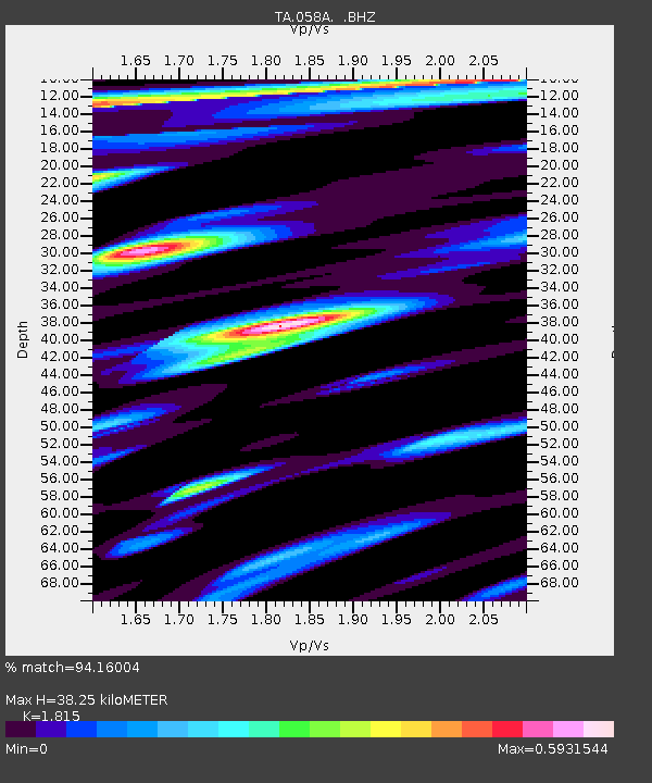
058A Arcadia, FL, USA - Earthquake Result Viewer
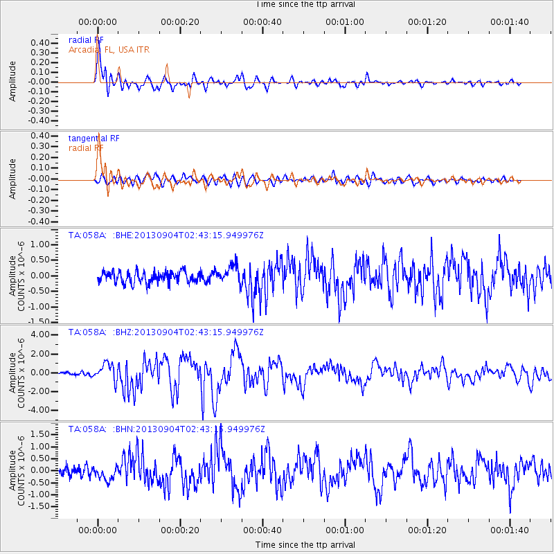
Earthquake location: Andreanof Islands, Aleutian Is.
Earthquake latitude/longitude: 51.6/-174.8
Earthquake time(UTC): 2013/09/04 (247) 02:32:30 GMT
Earthquake Depth: 20 km
Earthquake Magnitude: 6.5 MWW, 5.9 ML, 6.3 MWB, 6.5 MI, 6.5 MWC, 6.5 MWW
Earthquake Catalog/Contributor: NEIC PDE/NEIC COMCAT
Network: TA USArray Transportable Network (new EarthScope stations)
Station: 058A Arcadia, FL, USA
Lat/Lon: 27.06 N/81.80 W
Elevation: 15 m
Distance: 71.1 deg
Az: 70.324 deg
Baz: 318.763 deg
Ray Param: 0.054554798
Estimated Moho Depth: 38.25 km
Estimated Crust Vp/Vs: 1.82
Assumed Crust Vp: 6.347 km/s
Estimated Crust Vs: 3.497 km/s
Estimated Crust Poisson's Ratio: 0.28
Radial Match: 94.16004 %
Radial Bump: 400
Transverse Match: 76.24806 %
Transverse Bump: 400
SOD ConfigId: 626651
Insert Time: 2014-04-18 10:09:02.889 +0000
GWidth: 2.5
Max Bumps: 400
Tol: 0.001

Signal To Noise

ChannelStoNSTALTA
TA:058A: :BHZ:20130904T02:43:15.949976Z6.727679.4624676E-71.4065E-7
TA:058A: :BHN:20130904T02:43:15.949976Z1.62934152.7301527E-71.6756172E-7
TA:058A: :BHE:20130904T02:43:15.949976Z1.6744622.9849903E-71.7826564E-7
Arrivals
Ps5.1 SECOND
PpPs16 SECOND
PsPs/PpSs21 SECOND