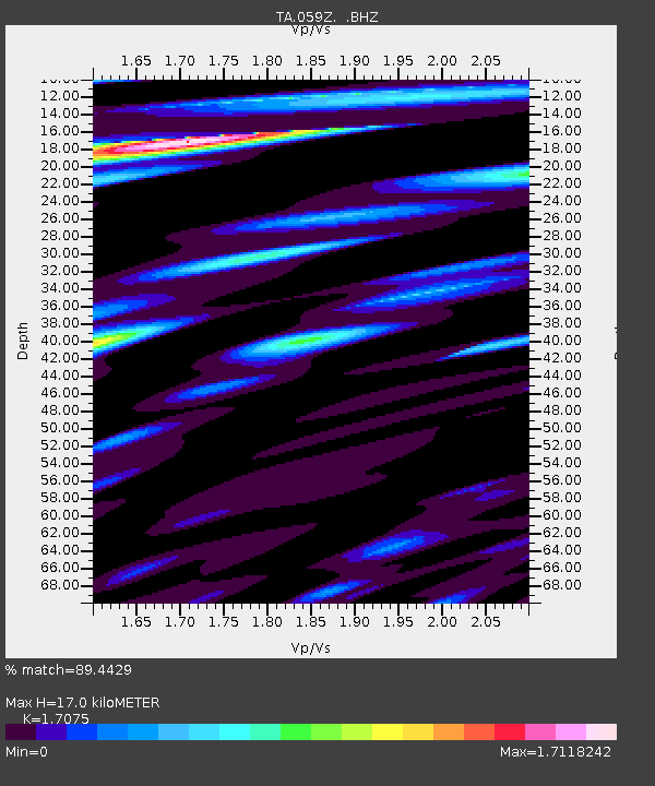
059Z Ave Maria, FL, USA - Earthquake Result Viewer
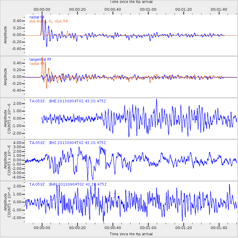
Earthquake location: Andreanof Islands, Aleutian Is.
Earthquake latitude/longitude: 51.6/-174.8
Earthquake time(UTC): 2013/09/04 (247) 02:32:30 GMT
Earthquake Depth: 20 km
Earthquake Magnitude: 6.5 MWW, 5.9 ML, 6.3 MWB, 6.5 MI, 6.5 MWC, 6.5 MWW
Earthquake Catalog/Contributor: NEIC PDE/NEIC COMCAT
Network: TA USArray Transportable Network (new EarthScope stations)
Station: 059Z Ave Maria, FL, USA
Lat/Lon: 26.34 N/81.44 W
Elevation: 8.0 m
Distance: 71.8 deg
Az: 70.564 deg
Baz: 319.001 deg
Ray Param: 0.05406214
Estimated Moho Depth: 17.0 km
Estimated Crust Vp/Vs: 1.71
Assumed Crust Vp: 6.347 km/s
Estimated Crust Vs: 3.717 km/s
Estimated Crust Poisson's Ratio: 0.24
Radial Match: 89.4429 %
Radial Bump: 400
Transverse Match: 74.742744 %
Transverse Bump: 400
SOD ConfigId: 626651
Insert Time: 2014-04-18 10:09:07.770 +0000
GWidth: 2.5
Max Bumps: 400
Tol: 0.001

Signal To Noise

ChannelStoNSTALTA
TA:059Z: :BHZ:20130904T02:43:20.475Z5.45681578.5611487E-71.5688909E-7
TA:059Z: :BHN:20130904T02:43:20.475Z1.6300534.9540864E-73.0392178E-7
TA:059Z: :BHE:20130904T02:43:20.475Z1.1596513.143454E-72.7106898E-7
Arrivals
Ps2.0 SECOND
PpPs7.0 SECOND
PsPs/PpSs9.0 SECOND