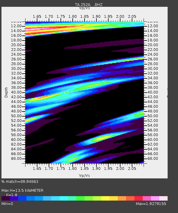
252A Lumpkin, GA, USA - Earthquake Result Viewer
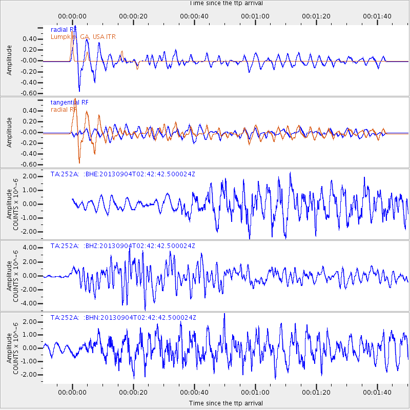
Earthquake location: Andreanof Islands, Aleutian Is.
Earthquake latitude/longitude: 51.6/-174.8
Earthquake time(UTC): 2013/09/04 (247) 02:32:30 GMT
Earthquake Depth: 20 km
Earthquake Magnitude: 6.5 MWW, 5.9 ML, 6.3 MWB, 6.5 MI, 6.5 MWC, 6.5 MWW
Earthquake Catalog/Contributor: NEIC PDE/NEIC COMCAT
Network: TA USArray Transportable Network (new EarthScope stations)
Station: 252A Lumpkin, GA, USA
Lat/Lon: 32.00 N/84.74 W
Elevation: 142 m
Distance: 65.7 deg
Az: 68.801 deg
Baz: 316.763 deg
Ray Param: 0.058083538
Estimated Moho Depth: 13.5 km
Estimated Crust Vp/Vs: 1.60
Assumed Crust Vp: 6.347 km/s
Estimated Crust Vs: 3.967 km/s
Estimated Crust Poisson's Ratio: 0.18
Radial Match: 89.94863 %
Radial Bump: 400
Transverse Match: 75.240585 %
Transverse Bump: 400
SOD ConfigId: 626651
Insert Time: 2014-04-18 10:09:43.828 +0000
GWidth: 2.5
Max Bumps: 400
Tol: 0.001

Signal To Noise

ChannelStoNSTALTA
TA:252A: :BHZ:20130904T02:42:42.500024Z8.5767479.870065E-71.1507935E-7
TA:252A: :BHN:20130904T02:42:42.500024Z1.23327463.278448E-72.6583277E-7
TA:252A: :BHE:20130904T02:42:42.500024Z1.43760944.5284514E-73.1499872E-7
Arrivals
Ps1.3 SECOND
PpPs5.3 SECOND
PsPs/PpSs6.6 SECOND