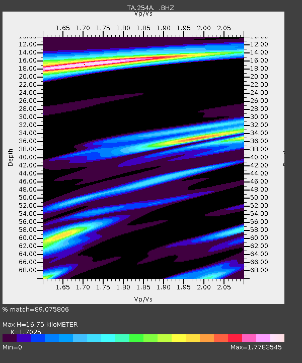
254A Abbeville, GA, USA - Earthquake Result Viewer
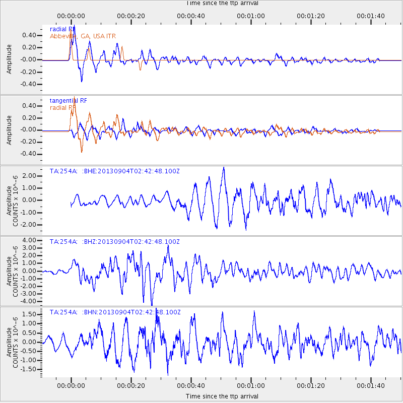
Earthquake location: Andreanof Islands, Aleutian Is.
Earthquake latitude/longitude: 51.6/-174.8
Earthquake time(UTC): 2013/09/04 (247) 02:32:30 GMT
Earthquake Depth: 20 km
Earthquake Magnitude: 6.5 MWW, 5.9 ML, 6.3 MWB, 6.5 MI, 6.5 MWC, 6.5 MWW
Earthquake Catalog/Contributor: NEIC PDE/NEIC COMCAT
Network: TA USArray Transportable Network (new EarthScope stations)
Station: 254A Abbeville, GA, USA
Lat/Lon: 31.95 N/83.29 W
Elevation: 78 m
Distance: 66.6 deg
Az: 67.857 deg
Baz: 317.142 deg
Ray Param: 0.05750936
Estimated Moho Depth: 16.75 km
Estimated Crust Vp/Vs: 1.70
Assumed Crust Vp: 6.565 km/s
Estimated Crust Vs: 3.856 km/s
Estimated Crust Poisson's Ratio: 0.24
Radial Match: 89.075806 %
Radial Bump: 400
Transverse Match: 70.75848 %
Transverse Bump: 400
SOD ConfigId: 626651
Insert Time: 2014-04-18 10:09:48.410 +0000
GWidth: 2.5
Max Bumps: 400
Tol: 0.001

Signal To Noise

ChannelStoNSTALTA
TA:254A: :BHZ:20130904T02:42:48.100Z7.72588449.605432E-71.2432793E-7
TA:254A: :BHN:20130904T02:42:48.100Z1.7435054.1196782E-72.3628715E-7
TA:254A: :BHE:20130904T02:42:48.100Z1.57838134.6273226E-72.9316888E-7
Arrivals
Ps1.9 SECOND
PpPs6.6 SECOND
PsPs/PpSs8.5 SECOND