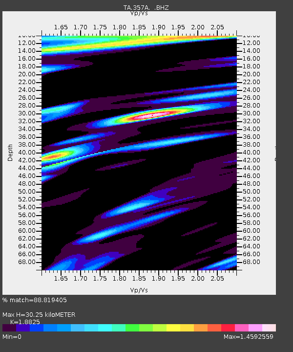
357A Townsend, GA, USA - Earthquake Result Viewer
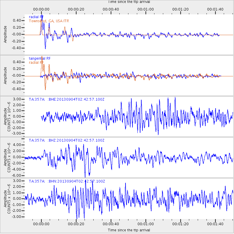
Earthquake location: Andreanof Islands, Aleutian Is.
Earthquake latitude/longitude: 51.6/-174.8
Earthquake time(UTC): 2013/09/04 (247) 02:32:30 GMT
Earthquake Depth: 20 km
Earthquake Magnitude: 6.5 MWW, 5.9 ML, 6.3 MWB, 6.5 MI, 6.5 MWC, 6.5 MWW
Earthquake Catalog/Contributor: NEIC PDE/NEIC COMCAT
Network: TA USArray Transportable Network (new EarthScope stations)
Station: 357A Townsend, GA, USA
Lat/Lon: 31.42 N/81.49 W
Elevation: 7.0 m
Distance: 68.0 deg
Az: 67.009 deg
Baz: 317.758 deg
Ray Param: 0.056575194
Estimated Moho Depth: 30.25 km
Estimated Crust Vp/Vs: 1.88
Assumed Crust Vp: 5.989 km/s
Estimated Crust Vs: 3.181 km/s
Estimated Crust Poisson's Ratio: 0.30
Radial Match: 88.819405 %
Radial Bump: 400
Transverse Match: 74.83086 %
Transverse Bump: 400
SOD ConfigId: 626651
Insert Time: 2014-04-18 10:10:07.309 +0000
GWidth: 2.5
Max Bumps: 400
Tol: 0.001

Signal To Noise

ChannelStoNSTALTA
TA:357A: :BHZ:20130904T02:42:57.100Z4.9020871.2470796E-62.5439766E-7
TA:357A: :BHN:20130904T02:42:57.100Z1.07770794.452339E-74.1313038E-7
TA:357A: :BHE:20130904T02:42:57.100Z1.58954697.399784E-74.655279E-7
Arrivals
Ps4.6 SECOND
PpPs14 SECOND
PsPs/PpSs19 SECOND