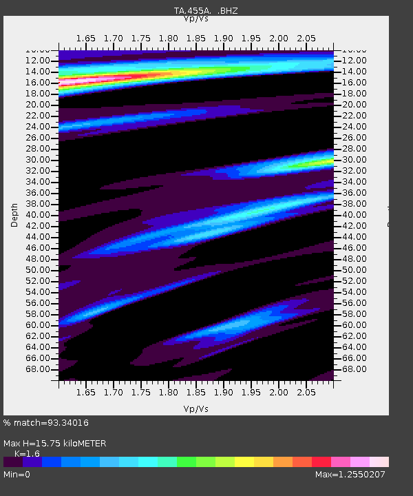
455A Stateville, GA, USA - Earthquake Result Viewer

Earthquake location: Andreanof Islands, Aleutian Is.
Earthquake latitude/longitude: 51.6/-174.8
Earthquake time(UTC): 2013/09/04 (247) 02:32:30 GMT
Earthquake Depth: 20 km
Earthquake Magnitude: 6.5 MWW, 5.9 ML, 6.3 MWB, 6.5 MI, 6.5 MWC, 6.5 MWW
Earthquake Catalog/Contributor: NEIC PDE/NEIC COMCAT
Network: TA USArray Transportable Network (new EarthScope stations)
Station: 455A Stateville, GA, USA
Lat/Lon: 30.74 N/83.03 W
Elevation: 44 m
Distance: 67.6 deg
Az: 68.559 deg
Baz: 317.553 deg
Ray Param: 0.056828033
Estimated Moho Depth: 15.75 km
Estimated Crust Vp/Vs: 1.60
Assumed Crust Vp: 6.565 km/s
Estimated Crust Vs: 4.103 km/s
Estimated Crust Poisson's Ratio: 0.18
Radial Match: 93.34016 %
Radial Bump: 400
Transverse Match: 79.52824 %
Transverse Bump: 400
SOD ConfigId: 626651
Insert Time: 2014-04-18 10:10:19.565 +0000
GWidth: 2.5
Max Bumps: 400
Tol: 0.001

Signal To Noise

ChannelStoNSTALTA
TA:455A: :BHZ:20130904T02:42:54.649988Z9.5645521.1003507E-61.15044664E-7
TA:455A: :BHN:20130904T02:42:54.649988Z3.20116734.3693132E-71.3649124E-7
TA:455A: :BHE:20130904T02:42:54.649988Z1.84586863.5714623E-71.9348411E-7
Arrivals
Ps1.5 SECOND
PpPs6.0 SECOND
PsPs/PpSs7.5 SECOND