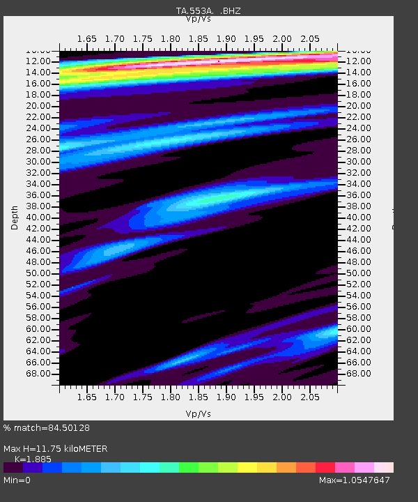
553A Crawfordville, FL, USA - Earthquake Result Viewer
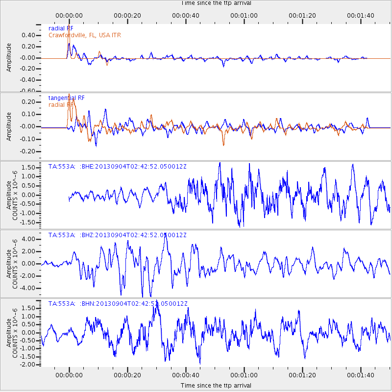
Earthquake location: Andreanof Islands, Aleutian Is.
Earthquake latitude/longitude: 51.6/-174.8
Earthquake time(UTC): 2013/09/04 (247) 02:32:30 GMT
Earthquake Depth: 20 km
Earthquake Magnitude: 6.5 MWW, 5.9 ML, 6.3 MWB, 6.5 MI, 6.5 MWC, 6.5 MWW
Earthquake Catalog/Contributor: NEIC PDE/NEIC COMCAT
Network: TA USArray Transportable Network (new EarthScope stations)
Station: 553A Crawfordville, FL, USA
Lat/Lon: 30.19 N/84.43 W
Elevation: 16 m
Distance: 67.2 deg
Az: 69.931 deg
Baz: 317.371 deg
Ray Param: 0.057097998
Estimated Moho Depth: 11.75 km
Estimated Crust Vp/Vs: 1.88
Assumed Crust Vp: 6.347 km/s
Estimated Crust Vs: 3.367 km/s
Estimated Crust Poisson's Ratio: 0.30
Radial Match: 84.50128 %
Radial Bump: 400
Transverse Match: 80.13133 %
Transverse Bump: 400
SOD ConfigId: 626651
Insert Time: 2014-04-18 10:10:25.775 +0000
GWidth: 2.5
Max Bumps: 400
Tol: 0.001

Signal To Noise

ChannelStoNSTALTA
TA:553A: :BHZ:20130904T02:42:52.050012Z3.6152941.1433835E-63.1626294E-7
TA:553A: :BHN:20130904T02:42:52.050012Z1.1353653.6055602E-73.1756838E-7
TA:553A: :BHE:20130904T02:42:52.050012Z1.82446113.8531286E-72.1119268E-7
Arrivals
Ps1.7 SECOND
PpPs5.1 SECOND
PsPs/PpSs6.8 SECOND