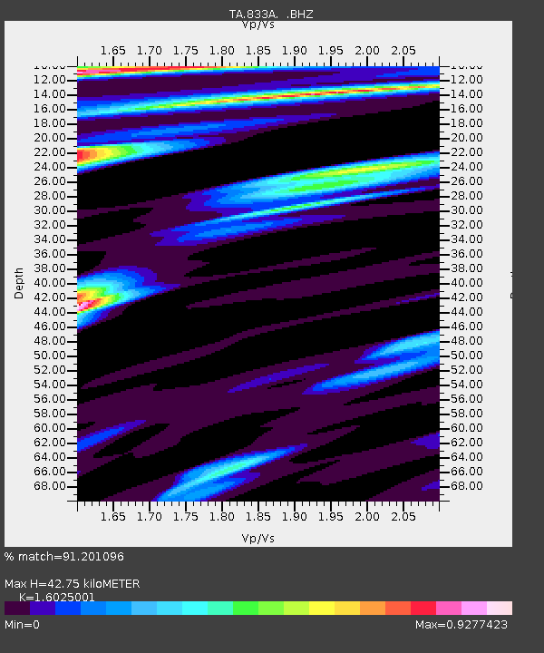
833A Chaparral WMA, Artesia Wells, TX, USA - Earthquake Result Viewer

Earthquake location: Andreanof Islands, Aleutian Is.
Earthquake latitude/longitude: 51.6/-174.8
Earthquake time(UTC): 2013/09/04 (247) 02:32:30 GMT
Earthquake Depth: 20 km
Earthquake Magnitude: 6.5 MWW, 5.9 ML, 6.3 MWB, 6.5 MI, 6.5 MWC, 6.5 MWW
Earthquake Catalog/Contributor: NEIC PDE/NEIC COMCAT
Network: TA USArray Transportable Network (new EarthScope stations)
Station: 833A Chaparral WMA, Artesia Wells, TX, USA
Lat/Lon: 28.32 N/99.39 W
Elevation: 171 m
Distance: 59.5 deg
Az: 81.944 deg
Baz: 315.481 deg
Ray Param: 0.062131092
Estimated Moho Depth: 42.75 km
Estimated Crust Vp/Vs: 1.60
Assumed Crust Vp: 6.347 km/s
Estimated Crust Vs: 3.961 km/s
Estimated Crust Poisson's Ratio: 0.18
Radial Match: 91.201096 %
Radial Bump: 400
Transverse Match: 83.02049 %
Transverse Bump: 400
SOD ConfigId: 626651
Insert Time: 2014-04-18 10:10:34.827 +0000
GWidth: 2.5
Max Bumps: 400
Tol: 0.001

Signal To Noise

ChannelStoNSTALTA
TA:833A: :BHZ:20130904T02:42:01.173975Z5.18998156.339472E-71.2214825E-7
TA:833A: :BHN:20130904T02:42:01.173975Z1.09279691.4154084E-71.2952162E-7
TA:833A: :BHE:20130904T02:42:01.173975Z0.73251191.482657E-72.0240722E-7
Arrivals
Ps4.3 SECOND
PpPs17 SECOND
PsPs/PpSs21 SECOND