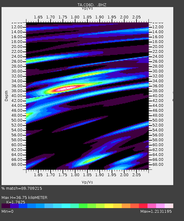
C06D Leavenworth, WQ, USA - Earthquake Result Viewer
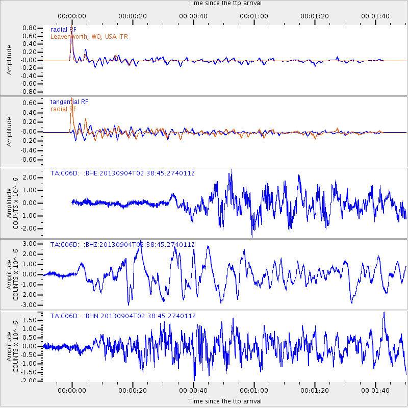
Earthquake location: Andreanof Islands, Aleutian Is.
Earthquake latitude/longitude: 51.6/-174.8
Earthquake time(UTC): 2013/09/04 (247) 02:32:30 GMT
Earthquake Depth: 20 km
Earthquake Magnitude: 6.5 MWW, 5.9 ML, 6.3 MWB, 6.5 MI, 6.5 MWC, 6.5 MWW
Earthquake Catalog/Contributor: NEIC PDE/NEIC COMCAT
Network: TA USArray Transportable Network (new EarthScope stations)
Station: C06D Leavenworth, WQ, USA
Lat/Lon: 47.92 N/120.89 W
Elevation: 544 m
Distance: 34.3 deg
Az: 74.35 deg
Baz: 296.65 deg
Ray Param: 0.07776574
Estimated Moho Depth: 36.75 km
Estimated Crust Vp/Vs: 1.76
Assumed Crust Vp: 6.597 km/s
Estimated Crust Vs: 3.743 km/s
Estimated Crust Poisson's Ratio: 0.26
Radial Match: 89.789215 %
Radial Bump: 362
Transverse Match: 76.62105 %
Transverse Bump: 400
SOD ConfigId: 626651
Insert Time: 2014-04-18 10:10:52.328 +0000
GWidth: 2.5
Max Bumps: 400
Tol: 0.001

Signal To Noise

ChannelStoNSTALTA
TA:C06D: :BHZ:20130904T02:38:45.274011Z3.88050465.7643115E-71.4854541E-7
TA:C06D: :BHN:20130904T02:38:45.274011Z1.48235291.9302797E-71.3021729E-7
TA:C06D: :BHE:20130904T02:38:45.274011Z2.46006973.192933E-71.2979035E-7
Arrivals
Ps4.6 SECOND
PpPs14 SECOND
PsPs/PpSs19 SECOND