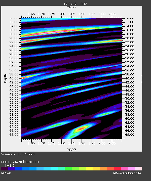
C40A Isle Royale National Park, MI, USA - Earthquake Result Viewer

Earthquake location: Andreanof Islands, Aleutian Is.
Earthquake latitude/longitude: 51.6/-174.8
Earthquake time(UTC): 2013/09/04 (247) 02:32:30 GMT
Earthquake Depth: 20 km
Earthquake Magnitude: 6.5 MWW, 5.9 ML, 6.3 MWB, 6.5 MI, 6.5 MWC, 6.5 MWW
Earthquake Catalog/Contributor: NEIC PDE/NEIC COMCAT
Network: TA USArray Transportable Network (new EarthScope stations)
Station: C40A Isle Royale National Park, MI, USA
Lat/Lon: 47.92 N/89.15 W
Elevation: 216 m
Distance: 52.4 deg
Az: 57.839 deg
Baz: 308.221 deg
Ray Param: 0.06675818
Estimated Moho Depth: 39.75 km
Estimated Crust Vp/Vs: 1.60
Assumed Crust Vp: 6.467 km/s
Estimated Crust Vs: 4.042 km/s
Estimated Crust Poisson's Ratio: 0.18
Radial Match: 81.548996 %
Radial Bump: 400
Transverse Match: 69.77119 %
Transverse Bump: 400
SOD ConfigId: 626651
Insert Time: 2014-04-18 10:10:54.518 +0000
GWidth: 2.5
Max Bumps: 400
Tol: 0.001

Signal To Noise

ChannelStoNSTALTA
TA:C40A: :BHZ:20130904T02:41:10.524988Z6.43247031.6784602E-62.6093556E-7
TA:C40A: :BHN:20130904T02:41:10.524988Z2.72000484.8637935E-71.7881563E-7
TA:C40A: :BHE:20130904T02:41:10.524988Z1.82965034.6720155E-72.553502E-7
Arrivals
Ps3.9 SECOND
PpPs15 SECOND
PsPs/PpSs19 SECOND