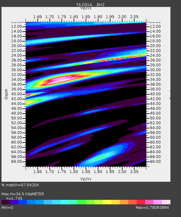
D51A Lot 18 Range III Mazenod Township, QC, CAN - Earthquake Result Viewer
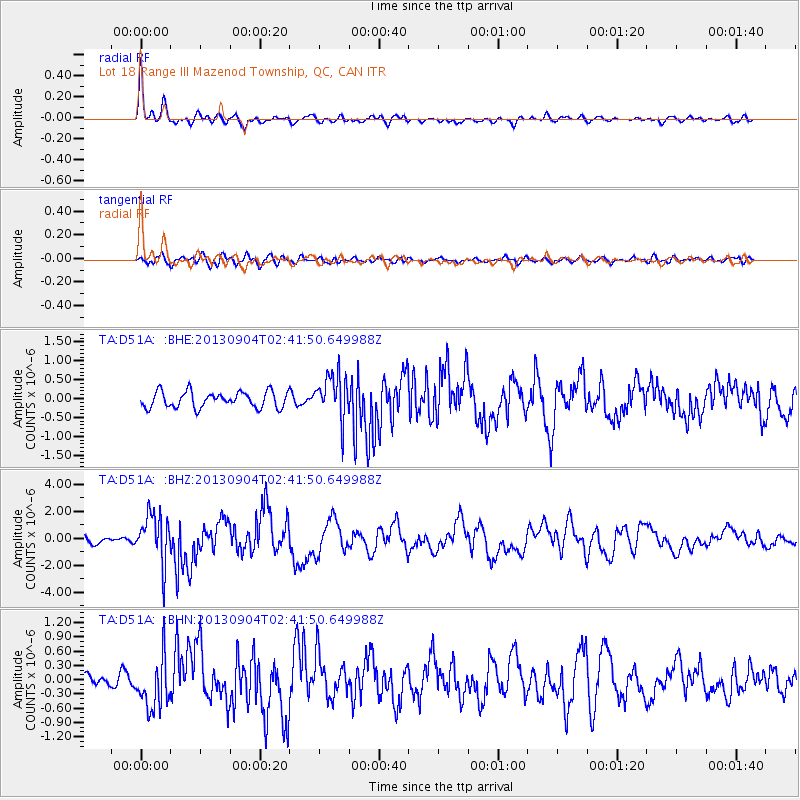
Earthquake location: Andreanof Islands, Aleutian Is.
Earthquake latitude/longitude: 51.6/-174.8
Earthquake time(UTC): 2013/09/04 (247) 02:32:30 GMT
Earthquake Depth: 20 km
Earthquake Magnitude: 6.5 MWW, 5.9 ML, 6.3 MWB, 6.5 MI, 6.5 MWC, 6.5 MWW
Earthquake Catalog/Contributor: NEIC PDE/NEIC COMCAT
Network: TA USArray Transportable Network (new EarthScope stations)
Station: D51A Lot 18 Range III Mazenod Township, QC, CAN
Lat/Lon: 47.09 N/79.37 W
Elevation: 282 m
Distance: 58.0 deg
Az: 53.357 deg
Baz: 312.854 deg
Ray Param: 0.06312284
Estimated Moho Depth: 34.5 km
Estimated Crust Vp/Vs: 1.74
Assumed Crust Vp: 6.622 km/s
Estimated Crust Vs: 3.817 km/s
Estimated Crust Poisson's Ratio: 0.25
Radial Match: 87.84204 %
Radial Bump: 400
Transverse Match: 79.74003 %
Transverse Bump: 400
SOD ConfigId: 626651
Insert Time: 2014-04-18 10:11:15.331 +0000
GWidth: 2.5
Max Bumps: 400
Tol: 0.001

Signal To Noise

ChannelStoNSTALTA
TA:D51A: :BHZ:20130904T02:41:50.649988Z7.55108831.8208654E-62.4113945E-7
TA:D51A: :BHN:20130904T02:41:50.649988Z3.45653465.3885003E-71.5589313E-7
TA:D51A: :BHE:20130904T02:41:50.649988Z2.7976245.9404505E-72.1233912E-7
Arrivals
Ps4.0 SECOND
PpPs14 SECOND
PsPs/PpSs18 SECOND