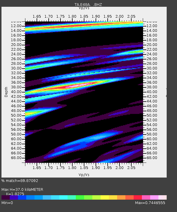
E48A Lockeyer, ON, CAN - Earthquake Result Viewer
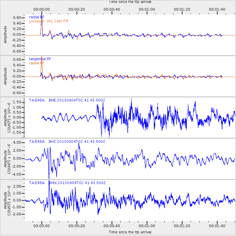
Earthquake location: Andreanof Islands, Aleutian Is.
Earthquake latitude/longitude: 51.6/-174.8
Earthquake time(UTC): 2013/09/04 (247) 02:32:30 GMT
Earthquake Depth: 20 km
Earthquake Magnitude: 6.5 MWW, 5.9 ML, 6.3 MWB, 6.5 MI, 6.5 MWC, 6.5 MWW
Earthquake Catalog/Contributor: NEIC PDE/NEIC COMCAT
Network: TA USArray Transportable Network (new EarthScope stations)
Station: E48A Lockeyer, ON, CAN
Lat/Lon: 46.48 N/82.17 W
Elevation: 347 m
Distance: 57.0 deg
Az: 55.425 deg
Baz: 311.938 deg
Ray Param: 0.063769795
Estimated Moho Depth: 37.0 km
Estimated Crust Vp/Vs: 1.83
Assumed Crust Vp: 6.467 km/s
Estimated Crust Vs: 3.539 km/s
Estimated Crust Poisson's Ratio: 0.29
Radial Match: 89.87092 %
Radial Bump: 400
Transverse Match: 63.62955 %
Transverse Bump: 400
SOD ConfigId: 626651
Insert Time: 2014-04-18 10:11:53.358 +0000
GWidth: 2.5
Max Bumps: 400
Tol: 0.001

Signal To Noise

ChannelStoNSTALTA
TA:E48A: :BHZ:20130904T02:41:43.600Z8.3485811.8119308E-62.1703457E-7
TA:E48A: :BHN:20130904T02:41:43.600Z4.7045959.244348E-71.9649613E-7
TA:E48A: :BHE:20130904T02:41:43.600Z3.46194036.730626E-71.9441774E-7
Arrivals
Ps5.0 SECOND
PpPs15 SECOND
PsPs/PpSs20 SECOND