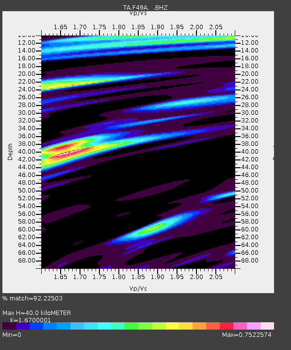
F49A Sandfield, ON, CAN - Earthquake Result Viewer
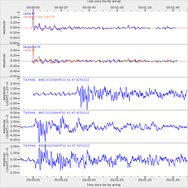
Earthquake location: Andreanof Islands, Aleutian Is.
Earthquake latitude/longitude: 51.6/-174.8
Earthquake time(UTC): 2013/09/04 (247) 02:32:30 GMT
Earthquake Depth: 20 km
Earthquake Magnitude: 6.5 MWW, 5.9 ML, 6.3 MWB, 6.5 MI, 6.5 MWC, 6.5 MWW
Earthquake Catalog/Contributor: NEIC PDE/NEIC COMCAT
Network: TA USArray Transportable Network (new EarthScope stations)
Station: F49A Sandfield, ON, CAN
Lat/Lon: 45.76 N/82.04 W
Elevation: 230 m
Distance: 57.5 deg
Az: 55.991 deg
Baz: 312.332 deg
Ray Param: 0.06341898
Estimated Moho Depth: 40.0 km
Estimated Crust Vp/Vs: 1.67
Assumed Crust Vp: 6.483 km/s
Estimated Crust Vs: 3.882 km/s
Estimated Crust Poisson's Ratio: 0.22
Radial Match: 92.22503 %
Radial Bump: 374
Transverse Match: 75.48353 %
Transverse Bump: 400
SOD ConfigId: 626651
Insert Time: 2014-04-18 10:12:32.197 +0000
GWidth: 2.5
Max Bumps: 400
Tol: 0.001

Signal To Noise

ChannelStoNSTALTA
TA:F49A: :BHZ:20130904T02:41:47.425012Z9.633992.228264E-62.3129192E-7
TA:F49A: :BHN:20130904T02:41:47.425012Z4.59168776.375482E-71.3884834E-7
TA:F49A: :BHE:20130904T02:41:47.425012Z5.0342658.6174674E-71.7117628E-7
Arrivals
Ps4.4 SECOND
PpPs16 SECOND
PsPs/PpSs20 SECOND