G57A Newington, ON, CAN - Earthquake Result Viewer
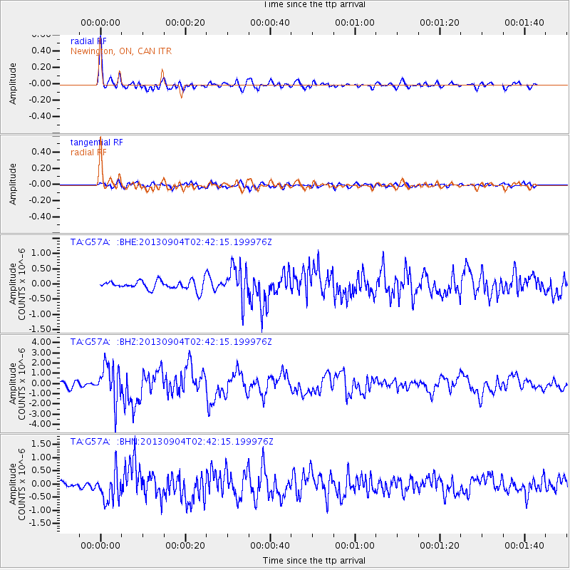
Earthquake location: Andreanof Islands, Aleutian Is.
Earthquake latitude/longitude: 51.6/-174.8
Earthquake time(UTC): 2013/09/04 (247) 02:32:30 GMT
Earthquake Depth: 20 km
Earthquake Magnitude: 6.5 MWW, 5.9 ML, 6.3 MWB, 6.5 MI, 6.5 MWC, 6.5 MWW
Earthquake Catalog/Contributor: NEIC PDE/NEIC COMCAT
Network: TA USArray Transportable Network (new EarthScope stations)
Station: G57A Newington, ON, CAN
Lat/Lon: 45.10 N/74.99 W
Elevation: 96 m
Distance: 61.5 deg
Az: 52.54 deg
Baz: 315.595 deg
Ray Param: 0.060781505
Estimated Moho Depth: 36.75 km
Estimated Crust Vp/Vs: 1.76
Assumed Crust Vp: 6.419 km/s
Estimated Crust Vs: 3.647 km/s
Estimated Crust Poisson's Ratio: 0.26
Radial Match: 85.56921 %
Radial Bump: 400
Transverse Match: 61.93761 %
Transverse Bump: 400
SOD ConfigId: 626651
Insert Time: 2014-04-18 10:13:13.994 +0000
GWidth: 2.5
Max Bumps: 400
Tol: 0.001

Signal To Noise

ChannelStoNSTALTA
TA:G57A: :BHZ:20130904T02:42:15.199976Z7.2328191.8054328E-62.4961676E-7
TA:G57A: :BHN:20130904T02:42:15.199976Z3.30435855.593283E-71.6926987E-7
TA:G57A: :BHE:20130904T02:42:15.199976Z3.71227245.532627E-71.4903613E-7
Arrivals
Ps4.6 SECOND
PpPs15 SECOND
PsPs/PpSs20 SECOND