You are here: Home > Network List > TA - USArray Transportable Network (new EarthScope stations) Stations List
> Station H17A Grant Village (NPS), Yellowstone Nt. Park, WY, USA > Earthquake Result Viewer
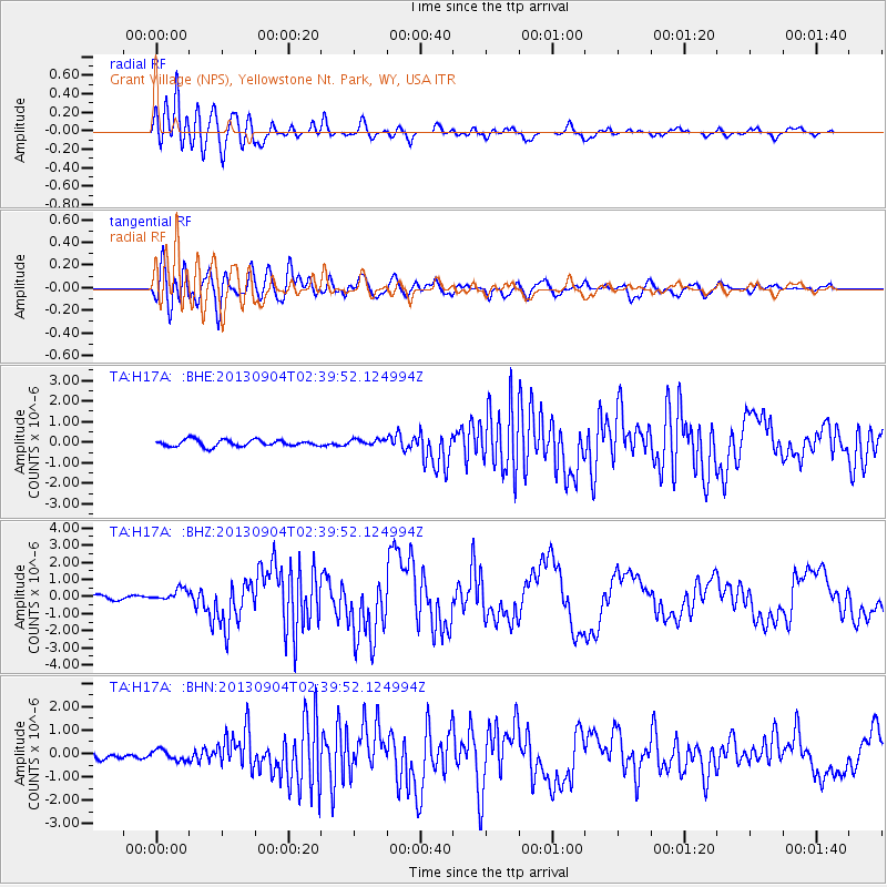
H17A Grant Village (NPS), Yellowstone Nt. Park, WY, USA - Earthquake Result Viewer
*The percent match for this event was below the threshold and hence no stack was calculated.
| Earthquake location: |
Andreanof Islands, Aleutian Is. |
| Earthquake latitude/longitude: |
51.6/-174.8 |
| Earthquake time(UTC): |
2013/09/04 (247) 02:32:30 GMT |
| Earthquake Depth: |
20 km |
| Earthquake Magnitude: |
6.5 MWW, 5.9 ML, 6.3 MWB, 6.5 MI, 6.5 MWC, 6.5 MWW |
| Earthquake Catalog/Contributor: |
NEIC PDE/NEIC COMCAT |
|
| Network: |
TA USArray Transportable Network (new EarthScope stations) |
| Station: |
H17A Grant Village (NPS), Yellowstone Nt. Park, WY, USA |
| Lat/Lon: |
44.40 N/110.58 W |
| Elevation: |
2400 m |
|
| Distance: |
42.3 deg |
| Az: |
73.478 deg |
| Baz: |
303.395 deg |
| Ray Param: |
$rayparam |
*The percent match for this event was below the threshold and hence was not used in the summary stack. |
|
| Radial Match: |
91.54031 % |
| Radial Bump: |
400 |
| Transverse Match: |
79.377975 % |
| Transverse Bump: |
400 |
| SOD ConfigId: |
626651 |
| Insert Time: |
2014-04-18 10:13:23.272 +0000 |
| GWidth: |
2.5 |
| Max Bumps: |
400 |
| Tol: |
0.001 |
|
Signal To Noise
| Channel | StoN | STA | LTA |
| TA:H17A: :BHZ:20130904T02:39:52.124994Z | 2.6552076 | 3.7729887E-7 | 1.4209769E-7 |
| TA:H17A: :BHN:20130904T02:39:52.124994Z | 1.0834517 | 2.2011798E-7 | 2.0316362E-7 |
| TA:H17A: :BHE:20130904T02:39:52.124994Z | 0.95084065 | 1.5249881E-7 | 1.6038315E-7 |
| Arrivals |
| Ps | |
| PpPs | |
| PsPs/PpSs | |


