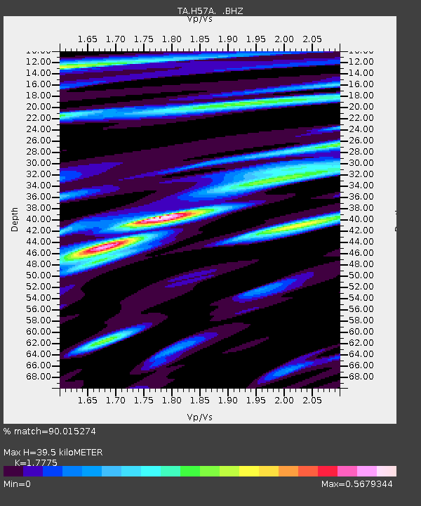
H57A Richville, NY, USA - Earthquake Result Viewer
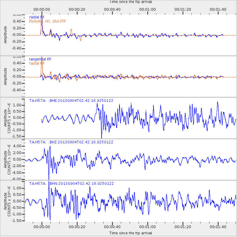
Earthquake location: Andreanof Islands, Aleutian Is.
Earthquake latitude/longitude: 51.6/-174.8
Earthquake time(UTC): 2013/09/04 (247) 02:32:30 GMT
Earthquake Depth: 20 km
Earthquake Magnitude: 6.5 MWW, 5.9 ML, 6.3 MWB, 6.5 MI, 6.5 MWC, 6.5 MWW
Earthquake Catalog/Contributor: NEIC PDE/NEIC COMCAT
Network: TA USArray Transportable Network (new EarthScope stations)
Station: H57A Richville, NY, USA
Lat/Lon: 44.46 N/75.39 W
Elevation: 132 m
Distance: 61.8 deg
Az: 53.284 deg
Baz: 315.663 deg
Ray Param: 0.06061899
Estimated Moho Depth: 39.5 km
Estimated Crust Vp/Vs: 1.78
Assumed Crust Vp: 6.419 km/s
Estimated Crust Vs: 3.611 km/s
Estimated Crust Poisson's Ratio: 0.27
Radial Match: 90.015274 %
Radial Bump: 400
Transverse Match: 74.67153 %
Transverse Bump: 400
SOD ConfigId: 626651
Insert Time: 2014-04-18 10:13:43.057 +0000
GWidth: 2.5
Max Bumps: 400
Tol: 0.001

Signal To Noise

ChannelStoNSTALTA
TA:H57A: :BHZ:20130904T02:42:16.925012Z10.9386332.2171666E-62.026914E-7
TA:H57A: :BHN:20130904T02:42:16.925012Z5.0536337.068327E-71.3986623E-7
TA:H57A: :BHE:20130904T02:42:16.925012Z3.65256956.8465073E-71.8744358E-7
Arrivals
Ps5.0 SECOND
PpPs16 SECOND
PsPs/PpSs21 SECOND