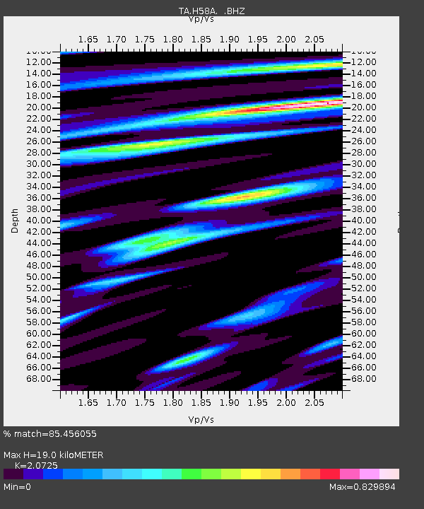
H58A Gabriels, NY, USA - Earthquake Result Viewer

Earthquake location: Andreanof Islands, Aleutian Is.
Earthquake latitude/longitude: 51.6/-174.8
Earthquake time(UTC): 2013/09/04 (247) 02:32:30 GMT
Earthquake Depth: 20 km
Earthquake Magnitude: 6.5 MWW, 5.9 ML, 6.3 MWB, 6.5 MI, 6.5 MWC, 6.5 MWW
Earthquake Catalog/Contributor: NEIC PDE/NEIC COMCAT
Network: TA USArray Transportable Network (new EarthScope stations)
Station: H58A Gabriels, NY, USA
Lat/Lon: 44.42 N/74.18 W
Elevation: 537 m
Distance: 62.4 deg
Az: 52.614 deg
Baz: 316.195 deg
Ray Param: 0.060202193
Estimated Moho Depth: 19.0 km
Estimated Crust Vp/Vs: 2.07
Assumed Crust Vp: 6.419 km/s
Estimated Crust Vs: 3.097 km/s
Estimated Crust Poisson's Ratio: 0.35
Radial Match: 85.456055 %
Radial Bump: 400
Transverse Match: 58.968307 %
Transverse Bump: 400
SOD ConfigId: 626651
Insert Time: 2014-04-18 10:13:44.902 +0000
GWidth: 2.5
Max Bumps: 400
Tol: 0.001

Signal To Noise

ChannelStoNSTALTA
TA:H58A: :BHZ:20130904T02:42:21.175012Z4.1186761.3668125E-63.3185722E-7
TA:H58A: :BHN:20130904T02:42:21.175012Z3.42145375.011258E-71.4646575E-7
TA:H58A: :BHE:20130904T02:42:21.175012Z2.8507324.567639E-71.6022688E-7
Arrivals
Ps3.3 SECOND
PpPs8.8 SECOND
PsPs/PpSs12 SECOND