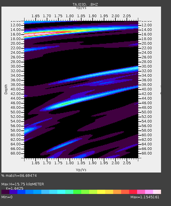
I03D Drain, OR, USA - Earthquake Result Viewer
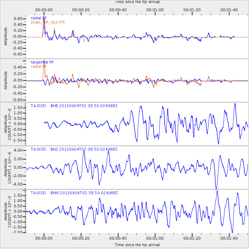
Earthquake location: Andreanof Islands, Aleutian Is.
Earthquake latitude/longitude: 51.6/-174.8
Earthquake time(UTC): 2013/09/04 (247) 02:32:30 GMT
Earthquake Depth: 20 km
Earthquake Magnitude: 6.5 MWW, 5.9 ML, 6.3 MWB, 6.5 MI, 6.5 MWC, 6.5 MWW
Earthquake Catalog/Contributor: NEIC PDE/NEIC COMCAT
Network: TA USArray Transportable Network (new EarthScope stations)
Station: I03D Drain, OR, USA
Lat/Lon: 43.70 N/123.35 W
Elevation: 140 m
Distance: 34.9 deg
Az: 82.324 deg
Baz: 301.46 deg
Ray Param: 0.07748023
Estimated Moho Depth: 15.75 km
Estimated Crust Vp/Vs: 1.64
Assumed Crust Vp: 6.522 km/s
Estimated Crust Vs: 3.971 km/s
Estimated Crust Poisson's Ratio: 0.21
Radial Match: 86.69474 %
Radial Bump: 400
Transverse Match: 66.144035 %
Transverse Bump: 400
SOD ConfigId: 626651
Insert Time: 2014-04-18 10:13:51.503 +0000
GWidth: 2.5
Max Bumps: 400
Tol: 0.001

Signal To Noise

ChannelStoNSTALTA
TA:I03D: :BHZ:20130904T02:38:50.024988Z2.39203244.164365E-71.7409317E-7
TA:I03D: :BHN:20130904T02:38:50.024988Z0.7196881.0178498E-71.4142931E-7
TA:I03D: :BHE:20130904T02:38:50.024988Z0.969770551.7391153E-71.7933266E-7
Arrivals
Ps1.7 SECOND
PpPs5.9 SECOND
PsPs/PpSs7.5 SECOND