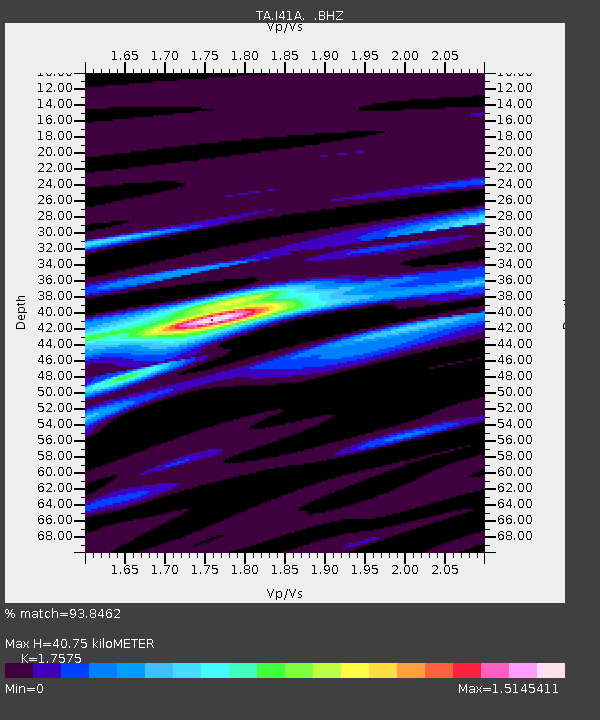
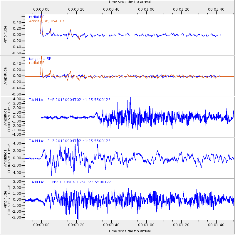
I41A Arkdale, WI, USA - Earthquake Result Viewer

Earthquake location: Andreanof Islands, Aleutian Is.
Earthquake latitude/longitude: 51.6/-174.8
Earthquake time(UTC): 2013/09/04 (247) 02:32:30 GMT
Earthquake Depth: 20 km
Earthquake Magnitude: 6.5 MWW, 5.9 ML, 6.3 MWB, 6.5 MI, 6.5 MWC, 6.5 MWW
Earthquake Catalog/Contributor: NEIC PDE/NEIC COMCAT
Network: TA USArray Transportable Network (new EarthScope stations)
Station: I41A Arkdale, WI, USA
Lat/Lon: 44.06 N/89.87 W
Elevation: 289 m
Distance: 54.5 deg
Az: 61.955 deg
Baz: 310.159 deg
Ray Param: 0.06541605
Estimated Moho Depth: 40.75 km
Estimated Crust Vp/Vs: 1.76
Assumed Crust Vp: 6.41 km/s
Estimated Crust Vs: 3.647 km/s
Estimated Crust Poisson's Ratio: 0.26
Radial Match: 93.8462 %
Radial Bump: 349
Transverse Match: 69.9821 %
Transverse Bump: 400
SOD ConfigId: 626651
Insert Time: 2014-04-18 10:13:57.653 +0000
GWidth: 2.5
Max Bumps: 400
Tol: 0.001

Signal To Noise

ChannelStoNSTALTA
TA:I41A: :BHZ:20130904T02:41:25.550012Z9.9198361.318874E-61.3295319E-7
TA:I41A: :BHN:20130904T02:41:25.550012Z2.99920854.3482623E-71.4498033E-7
TA:I41A: :BHE:20130904T02:41:25.550012Z4.2661565.6584423E-71.326356E-7
Arrivals
Ps5.1 SECOND
PpPs17 SECOND
PsPs/PpSs22 SECOND