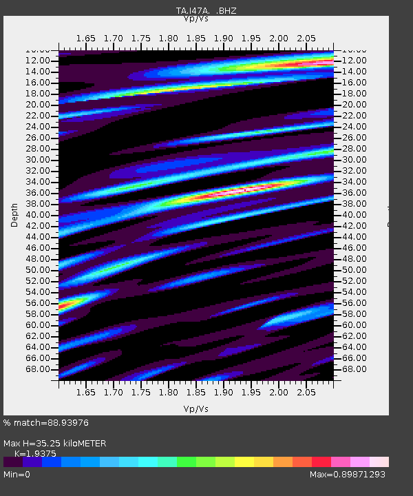
I47A Gladwin, MI, USA - Earthquake Result Viewer

Earthquake location: Andreanof Islands, Aleutian Is.
Earthquake latitude/longitude: 51.6/-174.8
Earthquake time(UTC): 2013/09/04 (247) 02:32:30 GMT
Earthquake Depth: 20 km
Earthquake Magnitude: 6.5 MWW, 5.9 ML, 6.3 MWB, 6.5 MI, 6.5 MWC, 6.5 MWW
Earthquake Catalog/Contributor: NEIC PDE/NEIC COMCAT
Network: TA USArray Transportable Network (new EarthScope stations)
Station: I47A Gladwin, MI, USA
Lat/Lon: 44.02 N/84.51 W
Elevation: 269 m
Distance: 57.4 deg
Az: 58.92 deg
Baz: 312.172 deg
Ray Param: 0.06349934
Estimated Moho Depth: 35.25 km
Estimated Crust Vp/Vs: 1.94
Assumed Crust Vp: 6.483 km/s
Estimated Crust Vs: 3.346 km/s
Estimated Crust Poisson's Ratio: 0.32
Radial Match: 88.93976 %
Radial Bump: 400
Transverse Match: 58.80747 %
Transverse Bump: 400
SOD ConfigId: 626651
Insert Time: 2014-04-18 10:14:07.088 +0000
GWidth: 2.5
Max Bumps: 400
Tol: 0.001

Signal To Noise

ChannelStoNSTALTA
TA:I47A: :BHZ:20130904T02:41:46.550012Z5.15477041.5133752E-62.935873E-7
TA:I47A: :BHN:20130904T02:41:46.550012Z1.73874095.149773E-72.9617826E-7
TA:I47A: :BHE:20130904T02:41:46.550012Z3.29942927.2419687E-72.1949157E-7
Arrivals
Ps5.3 SECOND
PpPs15 SECOND
PsPs/PpSs21 SECOND