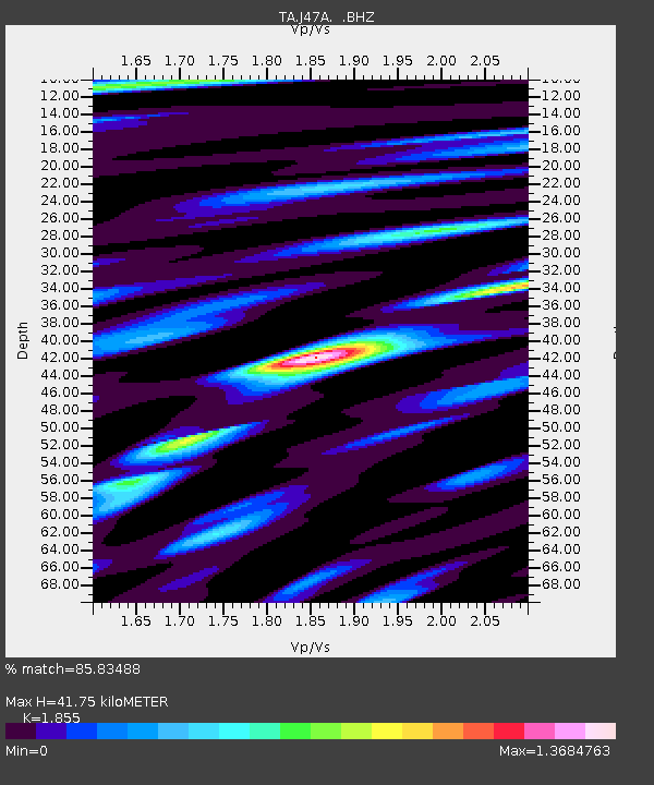
J47A Sunmer, MI, USA - Earthquake Result Viewer
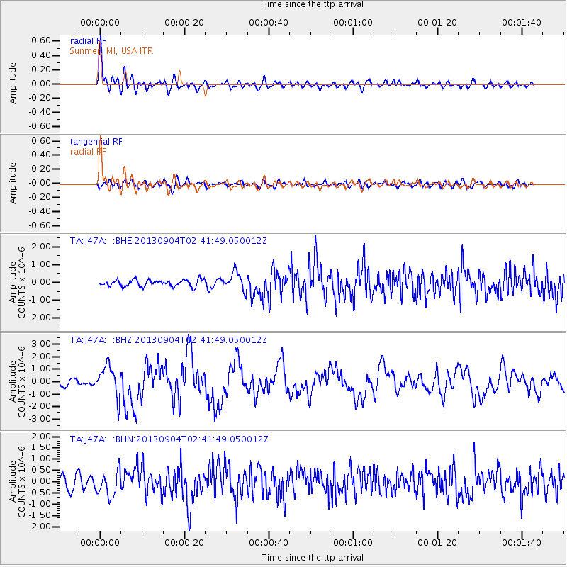
Earthquake location: Andreanof Islands, Aleutian Is.
Earthquake latitude/longitude: 51.6/-174.8
Earthquake time(UTC): 2013/09/04 (247) 02:32:30 GMT
Earthquake Depth: 20 km
Earthquake Magnitude: 6.5 MWW, 5.9 ML, 6.3 MWB, 6.5 MI, 6.5 MWC, 6.5 MWW
Earthquake Catalog/Contributor: NEIC PDE/NEIC COMCAT
Network: TA USArray Transportable Network (new EarthScope stations)
Station: J47A Sunmer, MI, USA
Lat/Lon: 43.24 N/84.82 W
Elevation: 236 m
Distance: 57.7 deg
Az: 59.785 deg
Baz: 312.422 deg
Ray Param: 0.06327139
Estimated Moho Depth: 41.75 km
Estimated Crust Vp/Vs: 1.86
Assumed Crust Vp: 6.483 km/s
Estimated Crust Vs: 3.495 km/s
Estimated Crust Poisson's Ratio: 0.30
Radial Match: 85.83488 %
Radial Bump: 400
Transverse Match: 71.38455 %
Transverse Bump: 400
SOD ConfigId: 626651
Insert Time: 2014-04-18 10:14:37.590 +0000
GWidth: 2.5
Max Bumps: 400
Tol: 0.001

Signal To Noise

ChannelStoNSTALTA
TA:J47A: :BHZ:20130904T02:41:49.050012Z6.50995351.2381728E-61.9019687E-7
TA:J47A: :BHN:20130904T02:41:49.050012Z2.5015275.611798E-72.2433487E-7
TA:J47A: :BHE:20130904T02:41:49.050012Z2.75378545.0156285E-71.8213579E-7
Arrivals
Ps5.8 SECOND
PpPs18 SECOND
PsPs/PpSs23 SECOND