K22A Casper, WY, USA - Earthquake Result Viewer
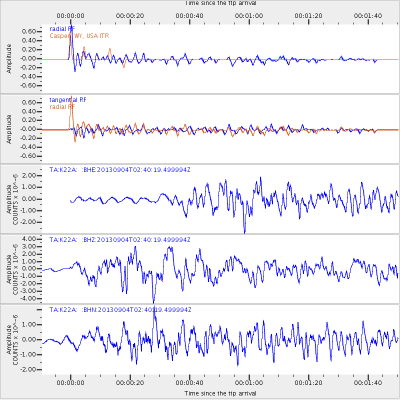
Earthquake location: Andreanof Islands, Aleutian Is.
Earthquake latitude/longitude: 51.6/-174.8
Earthquake time(UTC): 2013/09/04 (247) 02:32:30 GMT
Earthquake Depth: 20 km
Earthquake Magnitude: 6.5 MWW, 5.9 ML, 6.3 MWB, 6.5 MI, 6.5 MWC, 6.5 MWW
Earthquake Catalog/Contributor: NEIC PDE/NEIC COMCAT
Network: TA USArray Transportable Network (new EarthScope stations)
Station: K22A Casper, WY, USA
Lat/Lon: 42.65 N/106.52 W
Elevation: 1686 m
Distance: 45.7 deg
Az: 73.129 deg
Baz: 305.926 deg
Ray Param: 0.0710602
Estimated Moho Depth: 54.5 km
Estimated Crust Vp/Vs: 1.63
Assumed Crust Vp: 6.178 km/s
Estimated Crust Vs: 3.779 km/s
Estimated Crust Poisson's Ratio: 0.20
Radial Match: 89.91478 %
Radial Bump: 400
Transverse Match: 73.27235 %
Transverse Bump: 400
SOD ConfigId: 626651
Insert Time: 2014-04-18 10:15:03.848 +0000
GWidth: 2.5
Max Bumps: 400
Tol: 0.001

Signal To Noise

ChannelStoNSTALTA
TA:K22A: :BHZ:20130904T02:40:19.499994Z6.17862135.583455E-79.036734E-8
TA:K22A: :BHN:20130904T02:40:19.499994Z1.94100483.3469092E-71.724318E-7
TA:K22A: :BHE:20130904T02:40:19.499994Z1.99377783.1168238E-71.5632754E-7
Arrivals
Ps6.0 SECOND
PpPs22 SECOND
PsPs/PpSs28 SECOND