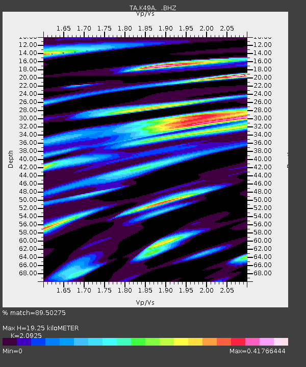
K49A Clarkson, MI, USA - Earthquake Result Viewer

Earthquake location: Andreanof Islands, Aleutian Is.
Earthquake latitude/longitude: 51.6/-174.8
Earthquake time(UTC): 2013/09/04 (247) 02:32:30 GMT
Earthquake Depth: 20 km
Earthquake Magnitude: 6.5 MWW, 5.9 ML, 6.3 MWB, 6.5 MI, 6.5 MWC, 6.5 MWW
Earthquake Catalog/Contributor: NEIC PDE/NEIC COMCAT
Network: TA USArray Transportable Network (new EarthScope stations)
Station: K49A Clarkson, MI, USA
Lat/Lon: 42.78 N/83.46 W
Elevation: 336 m
Distance: 58.8 deg
Az: 59.377 deg
Baz: 313.136 deg
Ray Param: 0.0625916
Estimated Moho Depth: 19.25 km
Estimated Crust Vp/Vs: 2.09
Assumed Crust Vp: 6.483 km/s
Estimated Crust Vs: 3.098 km/s
Estimated Crust Poisson's Ratio: 0.35
Radial Match: 89.50275 %
Radial Bump: 400
Transverse Match: 78.9294 %
Transverse Bump: 400
SOD ConfigId: 626651
Insert Time: 2014-04-18 10:15:16.769 +0000
GWidth: 2.5
Max Bumps: 400
Tol: 0.001

Signal To Noise

ChannelStoNSTALTA
TA:K49A: :BHZ:20130904T02:41:56.350Z11.2218331.7873582E-61.5927507E-7
TA:K49A: :BHN:20130904T02:41:56.350Z2.62861065.235902E-71.9918896E-7
TA:K49A: :BHE:20130904T02:41:56.350Z2.82693985.522197E-71.9534187E-7
Arrivals
Ps3.4 SECOND
PpPs8.8 SECOND
PsPs/PpSs12 SECOND