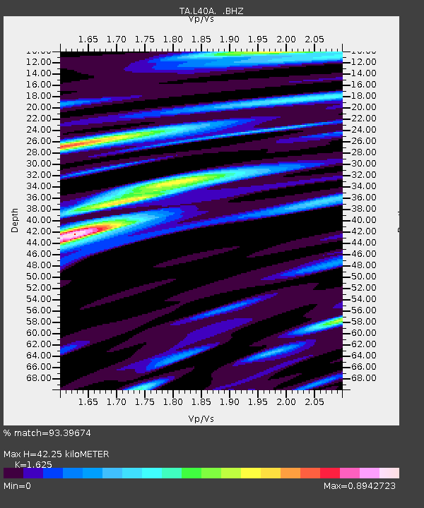
L40A Anamosa, IA, USA - Earthquake Result Viewer
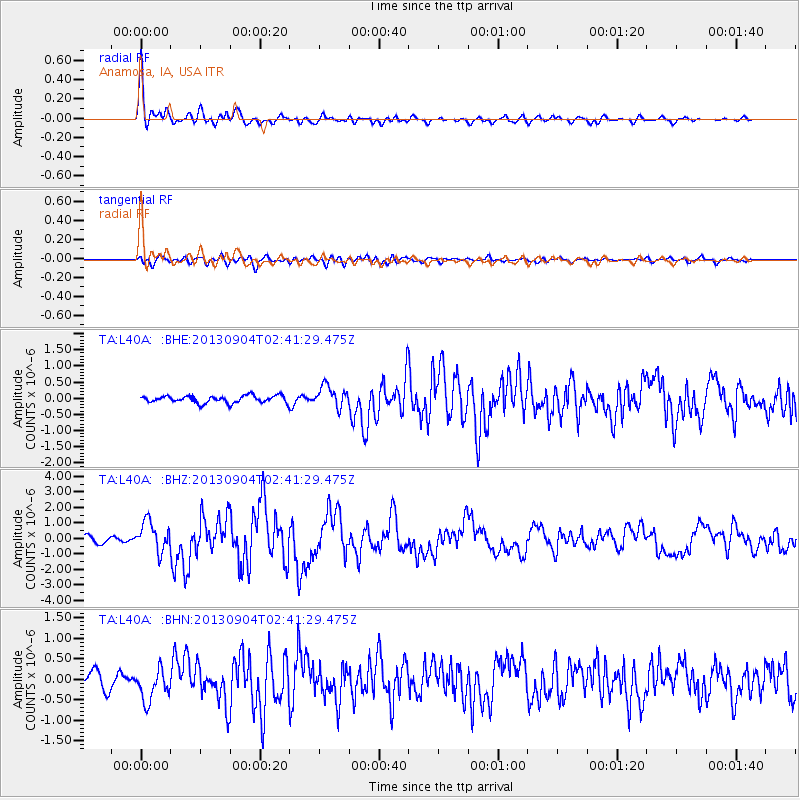
Earthquake location: Andreanof Islands, Aleutian Is.
Earthquake latitude/longitude: 51.6/-174.8
Earthquake time(UTC): 2013/09/04 (247) 02:32:30 GMT
Earthquake Depth: 20 km
Earthquake Magnitude: 6.5 MWW, 5.9 ML, 6.3 MWB, 6.5 MI, 6.5 MWC, 6.5 MWW
Earthquake Catalog/Contributor: NEIC PDE/NEIC COMCAT
Network: TA USArray Transportable Network (new EarthScope stations)
Station: L40A Anamosa, IA, USA
Lat/Lon: 42.06 N/91.22 W
Elevation: 242 m
Distance: 55.0 deg
Az: 64.603 deg
Baz: 310.769 deg
Ray Param: 0.06506406
Estimated Moho Depth: 42.25 km
Estimated Crust Vp/Vs: 1.62
Assumed Crust Vp: 6.53 km/s
Estimated Crust Vs: 4.019 km/s
Estimated Crust Poisson's Ratio: 0.20
Radial Match: 93.39674 %
Radial Bump: 400
Transverse Match: 74.805275 %
Transverse Bump: 400
SOD ConfigId: 626651
Insert Time: 2014-04-18 10:15:44.287 +0000
GWidth: 2.5
Max Bumps: 400
Tol: 0.001

Signal To Noise

ChannelStoNSTALTA
TA:L40A: :BHZ:20130904T02:41:29.475Z5.9207549.514565E-71.6069853E-7
TA:L40A: :BHN:20130904T02:41:29.475Z2.3225773.921408E-71.6883867E-7
TA:L40A: :BHE:20130904T02:41:29.475Z2.92533233.2651587E-71.1161667E-7
Arrivals
Ps4.3 SECOND
PpPs16 SECOND
PsPs/PpSs20 SECOND