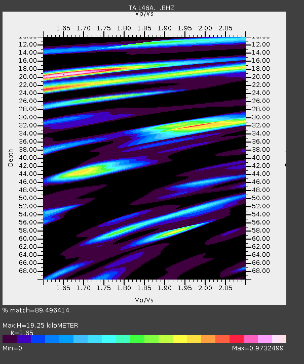
L46A Eue Claire, MI, USA - Earthquake Result Viewer

Earthquake location: Andreanof Islands, Aleutian Is.
Earthquake latitude/longitude: 51.6/-174.8
Earthquake time(UTC): 2013/09/04 (247) 02:32:30 GMT
Earthquake Depth: 20 km
Earthquake Magnitude: 6.5 MWW, 5.9 ML, 6.3 MWB, 6.5 MI, 6.5 MWC, 6.5 MWW
Earthquake Catalog/Contributor: NEIC PDE/NEIC COMCAT
Network: TA USArray Transportable Network (new EarthScope stations)
Station: L46A Eue Claire, MI, USA
Lat/Lon: 42.01 N/86.30 W
Elevation: 223 m
Distance: 57.8 deg
Az: 61.722 deg
Baz: 312.46 deg
Ray Param: 0.063256375
Estimated Moho Depth: 19.25 km
Estimated Crust Vp/Vs: 1.65
Assumed Crust Vp: 6.483 km/s
Estimated Crust Vs: 3.929 km/s
Estimated Crust Poisson's Ratio: 0.21
Radial Match: 89.496414 %
Radial Bump: 400
Transverse Match: 67.050606 %
Transverse Bump: 400
SOD ConfigId: 626651
Insert Time: 2014-04-18 10:15:54.234 +0000
GWidth: 2.5
Max Bumps: 400
Tol: 0.001

Signal To Noise

ChannelStoNSTALTA
TA:L46A: :BHZ:20130904T02:41:49.225Z7.02781061.0933204E-61.5557056E-7
TA:L46A: :BHN:20130904T02:41:49.225Z3.34606395.830404E-71.7424664E-7
TA:L46A: :BHE:20130904T02:41:49.225Z3.01781735.2887276E-71.7525011E-7
Arrivals
Ps2.0 SECOND
PpPs7.5 SECOND
PsPs/PpSs9.5 SECOND