M41A Milan, IL, USA - Earthquake Result Viewer
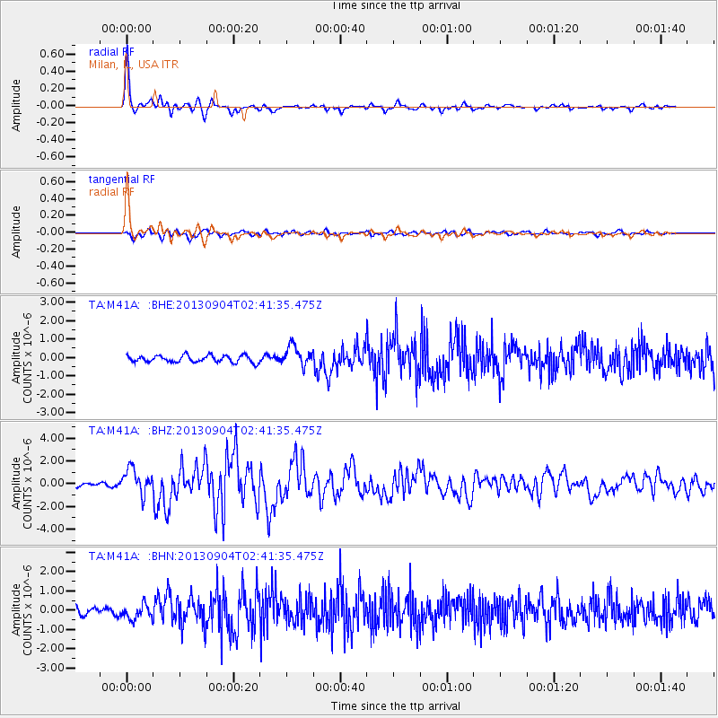
Earthquake location: Andreanof Islands, Aleutian Is.
Earthquake latitude/longitude: 51.6/-174.8
Earthquake time(UTC): 2013/09/04 (247) 02:32:30 GMT
Earthquake Depth: 20 km
Earthquake Magnitude: 6.5 MWW, 5.9 ML, 6.3 MWB, 6.5 MI, 6.5 MWC, 6.5 MWW
Earthquake Catalog/Contributor: NEIC PDE/NEIC COMCAT
Network: TA USArray Transportable Network (new EarthScope stations)
Station: M41A Milan, IL, USA
Lat/Lon: 41.38 N/90.54 W
Elevation: 226 m
Distance: 55.8 deg
Az: 64.826 deg
Baz: 311.346 deg
Ray Param: 0.06451539
Estimated Moho Depth: 14.25 km
Estimated Crust Vp/Vs: 2.01
Assumed Crust Vp: 6.498 km/s
Estimated Crust Vs: 3.241 km/s
Estimated Crust Poisson's Ratio: 0.33
Radial Match: 92.4573 %
Radial Bump: 358
Transverse Match: 74.553246 %
Transverse Bump: 400
SOD ConfigId: 626651
Insert Time: 2014-04-18 10:16:24.637 +0000
GWidth: 2.5
Max Bumps: 400
Tol: 0.001

Signal To Noise

ChannelStoNSTALTA
TA:M41A: :BHZ:20130904T02:41:35.475Z6.7773091.1364885E-61.6769025E-7
TA:M41A: :BHN:20130904T02:41:35.475Z1.95776653.7378214E-71.9092273E-7
TA:M41A: :BHE:20130904T02:41:35.475Z2.9317015.4198966E-71.8487209E-7
Arrivals
Ps2.3 SECOND
PpPs6.3 SECOND
PsPs/PpSs8.6 SECOND