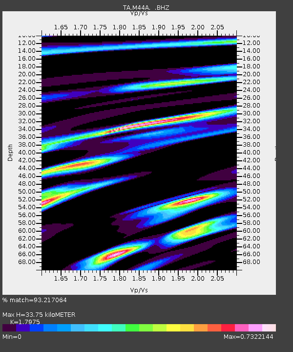
M44A Midewin, Midewin Nat. Tallgrass Prarie, IL, USA - Earthquake Result Viewer

Earthquake location: Andreanof Islands, Aleutian Is.
Earthquake latitude/longitude: 51.6/-174.8
Earthquake time(UTC): 2013/09/04 (247) 02:32:30 GMT
Earthquake Depth: 20 km
Earthquake Magnitude: 6.5 MWW, 5.9 ML, 6.3 MWB, 6.5 MI, 6.5 MWC, 6.5 MWW
Earthquake Catalog/Contributor: NEIC PDE/NEIC COMCAT
Network: TA USArray Transportable Network (new EarthScope stations)
Station: M44A Midewin, Midewin Nat. Tallgrass Prarie, IL, USA
Lat/Lon: 41.39 N/88.04 W
Elevation: 207 m
Distance: 57.2 deg
Az: 63.313 deg
Baz: 312.157 deg
Ray Param: 0.06360522
Estimated Moho Depth: 33.75 km
Estimated Crust Vp/Vs: 1.80
Assumed Crust Vp: 6.498 km/s
Estimated Crust Vs: 3.615 km/s
Estimated Crust Poisson's Ratio: 0.28
Radial Match: 93.217064 %
Radial Bump: 400
Transverse Match: 55.718216 %
Transverse Bump: 400
SOD ConfigId: 626651
Insert Time: 2014-04-18 10:16:27.721 +0000
GWidth: 2.5
Max Bumps: 400
Tol: 0.001

Signal To Noise

ChannelStoNSTALTA
TA:M44A: :BHZ:20130904T02:41:45.373987Z6.6120291.3044111E-61.972785E-7
TA:M44A: :BHN:20130904T02:41:45.373987Z2.30401094.7368295E-72.0559058E-7
TA:M44A: :BHE:20130904T02:41:45.373987Z3.50269536.0153366E-71.7173451E-7
Arrivals
Ps4.4 SECOND
PpPs14 SECOND
PsPs/PpSs18 SECOND