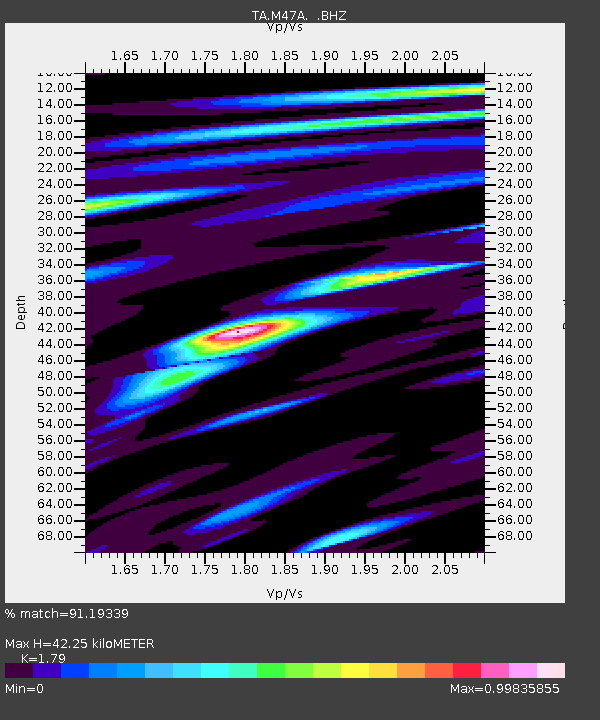
M47A Cromwell, IN, USA - Earthquake Result Viewer
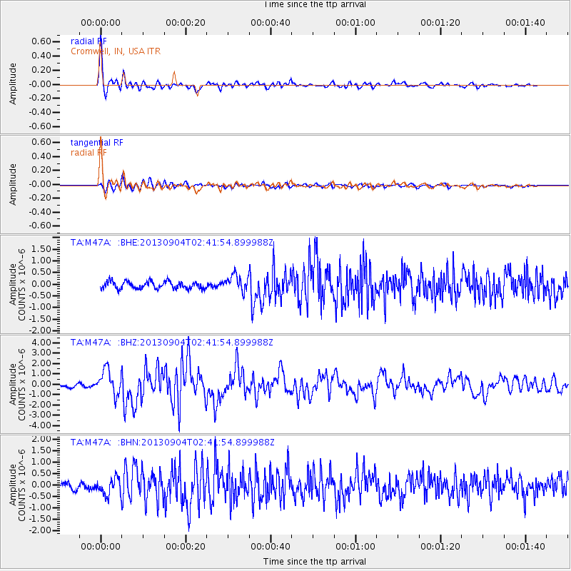
Earthquake location: Andreanof Islands, Aleutian Is.
Earthquake latitude/longitude: 51.6/-174.8
Earthquake time(UTC): 2013/09/04 (247) 02:32:30 GMT
Earthquake Depth: 20 km
Earthquake Magnitude: 6.5 MWW, 5.9 ML, 6.3 MWB, 6.5 MI, 6.5 MWC, 6.5 MWW
Earthquake Catalog/Contributor: NEIC PDE/NEIC COMCAT
Network: TA USArray Transportable Network (new EarthScope stations)
Station: M47A Cromwell, IN, USA
Lat/Lon: 41.36 N/85.62 W
Elevation: 283 m
Distance: 58.6 deg
Az: 61.883 deg
Baz: 312.992 deg
Ray Param: 0.062726215
Estimated Moho Depth: 42.25 km
Estimated Crust Vp/Vs: 1.79
Assumed Crust Vp: 6.498 km/s
Estimated Crust Vs: 3.63 km/s
Estimated Crust Poisson's Ratio: 0.27
Radial Match: 91.19339 %
Radial Bump: 400
Transverse Match: 79.18132 %
Transverse Bump: 400
SOD ConfigId: 626651
Insert Time: 2014-04-18 10:16:29.511 +0000
GWidth: 2.5
Max Bumps: 400
Tol: 0.001

Signal To Noise

ChannelStoNSTALTA
TA:M47A: :BHZ:20130904T02:41:54.899988Z7.69737531.2288874E-61.5965018E-7
TA:M47A: :BHN:20130904T02:41:54.899988Z1.94222893.7301206E-71.920536E-7
TA:M47A: :BHE:20130904T02:41:54.899988Z2.25633123.4998624E-71.5511296E-7
Arrivals
Ps5.4 SECOND
PpPs17 SECOND
PsPs/PpSs23 SECOND