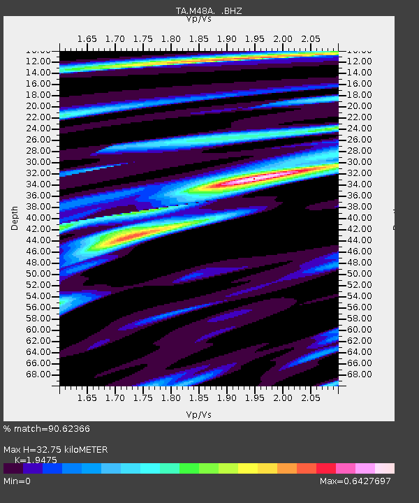
M48A Edgerton, OH, USA - Earthquake Result Viewer
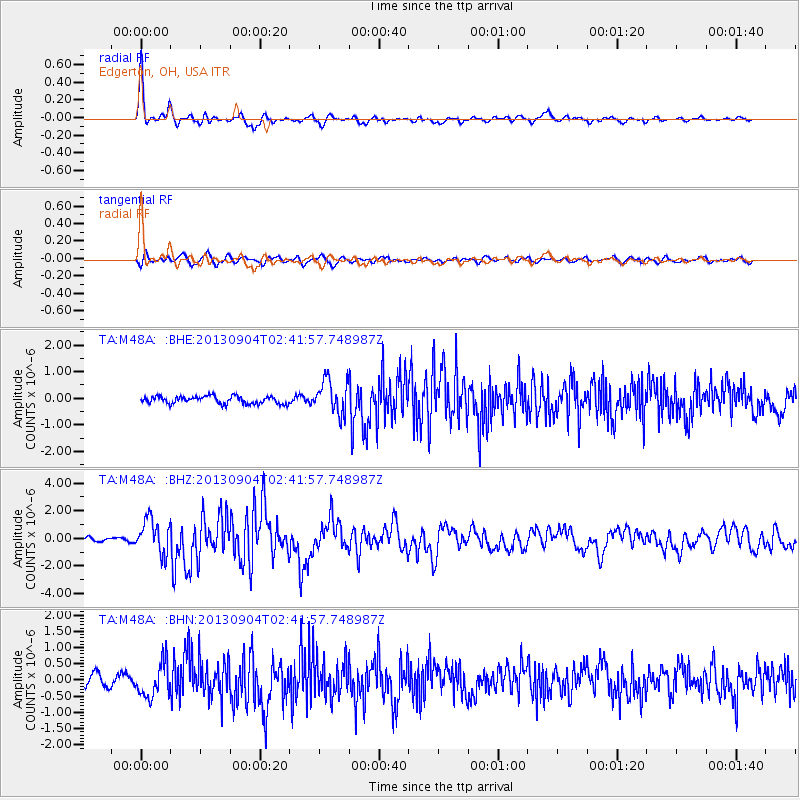
Earthquake location: Andreanof Islands, Aleutian Is.
Earthquake latitude/longitude: 51.6/-174.8
Earthquake time(UTC): 2013/09/04 (247) 02:32:30 GMT
Earthquake Depth: 20 km
Earthquake Magnitude: 6.5 MWW, 5.9 ML, 6.3 MWB, 6.5 MI, 6.5 MWC, 6.5 MWW
Earthquake Catalog/Contributor: NEIC PDE/NEIC COMCAT
Network: TA USArray Transportable Network (new EarthScope stations)
Station: M48A Edgerton, OH, USA
Lat/Lon: 41.48 N/84.72 W
Elevation: 258 m
Distance: 59.0 deg
Az: 61.233 deg
Baz: 313.251 deg
Ray Param: 0.062458362
Estimated Moho Depth: 32.75 km
Estimated Crust Vp/Vs: 1.95
Assumed Crust Vp: 6.498 km/s
Estimated Crust Vs: 3.336 km/s
Estimated Crust Poisson's Ratio: 0.32
Radial Match: 90.62366 %
Radial Bump: 369
Transverse Match: 70.332275 %
Transverse Bump: 400
SOD ConfigId: 626651
Insert Time: 2014-04-18 10:16:32.420 +0000
GWidth: 2.5
Max Bumps: 400
Tol: 0.001

Signal To Noise

ChannelStoNSTALTA
TA:M48A: :BHZ:20130904T02:41:57.748987Z7.027391.2316709E-61.7526719E-7
TA:M48A: :BHN:20130904T02:41:57.748987Z3.52173855.153522E-71.4633461E-7
TA:M48A: :BHE:20130904T02:41:57.748987Z4.5999616.309522E-71.3716468E-7
Arrivals
Ps5.0 SECOND
PpPs14 SECOND
PsPs/PpSs19 SECOND