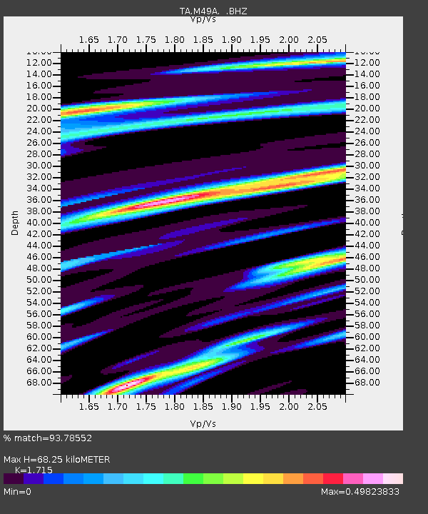
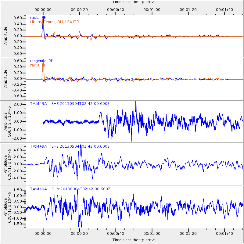
M49A Liberty Center, OH, USA - Earthquake Result Viewer

Earthquake location: Andreanof Islands, Aleutian Is.
Earthquake latitude/longitude: 51.6/-174.8
Earthquake time(UTC): 2013/09/04 (247) 02:32:30 GMT
Earthquake Depth: 20 km
Earthquake Magnitude: 6.5 MWW, 5.9 ML, 6.3 MWB, 6.5 MI, 6.5 MWC, 6.5 MWW
Earthquake Catalog/Contributor: NEIC PDE/NEIC COMCAT
Network: TA USArray Transportable Network (new EarthScope stations)
Station: M49A Liberty Center, OH, USA
Lat/Lon: 41.47 N/83.98 W
Elevation: 203 m
Distance: 59.4 deg
Az: 60.795 deg
Baz: 313.517 deg
Ray Param: 0.06218579
Estimated Moho Depth: 68.25 km
Estimated Crust Vp/Vs: 1.72
Assumed Crust Vp: 6.498 km/s
Estimated Crust Vs: 3.789 km/s
Estimated Crust Poisson's Ratio: 0.24
Radial Match: 93.78552 %
Radial Bump: 286
Transverse Match: 81.68564 %
Transverse Bump: 400
SOD ConfigId: 626651
Insert Time: 2014-04-18 10:16:33.726 +0000
GWidth: 2.5
Max Bumps: 400
Tol: 0.001

Signal To Noise

ChannelStoNSTALTA
TA:M49A: :BHZ:20130904T02:42:00.600Z8.6583941.1788773E-61.3615427E-7
TA:M49A: :BHN:20130904T02:42:00.600Z3.49436555.0874434E-71.455899E-7
TA:M49A: :BHE:20130904T02:42:00.600Z4.89452746.0132476E-71.2285656E-7
Arrivals
Ps7.9 SECOND
PpPs27 SECOND
PsPs/PpSs35 SECOND